You are here: Home > Network List > TA - USArray Transportable Network (new EarthScope stations) Stations List
> Station G26K Porcupine River, AK, USA > Earthquake Result Viewer
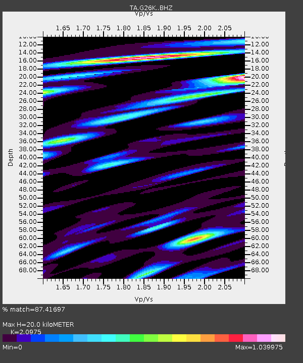
G26K Porcupine River, AK, USA - Earthquake Result Viewer
| Earthquake location: |
Myanmar |
| Earthquake latitude/longitude: |
22.8/94.0 |
| Earthquake time(UTC): |
2020/04/16 (107) 11:45:23 GMT |
| Earthquake Depth: |
10 km |
| Earthquake Magnitude: |
5.9 mww |
| Earthquake Catalog/Contributor: |
NEIC PDE/us |
|
| Network: |
TA USArray Transportable Network (new EarthScope stations) |
| Station: |
G26K Porcupine River, AK, USA |
| Lat/Lon: |
66.95 N/143.78 W |
| Elevation: |
180 m |
|
| Distance: |
80.8 deg |
| Az: |
19.731 deg |
| Baz: |
307.695 deg |
| Ray Param: |
0.048048995 |
| Estimated Moho Depth: |
20.0 km |
| Estimated Crust Vp/Vs: |
2.10 |
| Assumed Crust Vp: |
6.577 km/s |
| Estimated Crust Vs: |
3.136 km/s |
| Estimated Crust Poisson's Ratio: |
0.35 |
|
| Radial Match: |
87.41697 % |
| Radial Bump: |
400 |
| Transverse Match: |
81.98802 % |
| Transverse Bump: |
400 |
| SOD ConfigId: |
21166931 |
| Insert Time: |
2020-04-30 11:56:34.854 +0000 |
| GWidth: |
2.5 |
| Max Bumps: |
400 |
| Tol: |
0.001 |
|

Signal To Noise
| Channel | StoN | STA | LTA |
| TA:G26K: :BHZ:20200416T11:57:06.125006Z | 5.1792736 | 5.114905E-7 | 9.875719E-8 |
| TA:G26K: :BHN:20200416T11:57:06.125006Z | 1.8803657 | 2.0156433E-7 | 1.07194225E-7 |
| TA:G26K: :BHE:20200416T11:57:06.125006Z | 1.2018937 | 9.8858784E-8 | 8.225252E-8 |
| Arrivals |
| Ps | 3.4 SECOND |
| PpPs | 9.2 SECOND |
| PsPs/PpSs | 13 SECOND |


