You are here: Home > Network List > TA - USArray Transportable Network (new EarthScope stations) Stations List
> Station G31M Satah River, YT, CAN > Earthquake Result Viewer
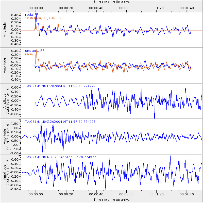
G31M Satah River, YT, CAN - Earthquake Result Viewer
*The percent match for this event was below the threshold and hence no stack was calculated.
| Earthquake location: |
Myanmar |
| Earthquake latitude/longitude: |
22.8/94.0 |
| Earthquake time(UTC): |
2020/04/16 (107) 11:45:23 GMT |
| Earthquake Depth: |
10 km |
| Earthquake Magnitude: |
5.9 mww |
| Earthquake Catalog/Contributor: |
NEIC PDE/us |
|
| Network: |
TA USArray Transportable Network (new EarthScope stations) |
| Station: |
G31M Satah River, YT, CAN |
| Lat/Lon: |
66.92 N/134.27 W |
| Elevation: |
61 m |
|
| Distance: |
83.6 deg |
| Az: |
17.227 deg |
| Baz: |
316.102 deg |
| Ray Param: |
$rayparam |
*The percent match for this event was below the threshold and hence was not used in the summary stack. |
|
| Radial Match: |
57.605663 % |
| Radial Bump: |
400 |
| Transverse Match: |
49.530647 % |
| Transverse Bump: |
400 |
| SOD ConfigId: |
21166931 |
| Insert Time: |
2020-04-30 11:56:40.446 +0000 |
| GWidth: |
2.5 |
| Max Bumps: |
400 |
| Tol: |
0.001 |
|
Signal To Noise
| Channel | StoN | STA | LTA |
| TA:G31M: :BHZ:20200416T11:57:20.77497Z | 6.1597023 | 7.3724823E-7 | 1.1968893E-7 |
| TA:G31M: :BHN:20200416T11:57:20.77497Z | 1.718732 | 2.4560578E-7 | 1.428994E-7 |
| TA:G31M: :BHE:20200416T11:57:20.77497Z | 1.321761 | 1.9310174E-7 | 1.4609428E-7 |
| Arrivals |
| Ps | |
| PpPs | |
| PsPs/PpSs | |


