You are here: Home > Network List > TA - USArray Transportable Network (new EarthScope stations) Stations List
> Station M31M Drury Creek, Yukon, CA > Earthquake Result Viewer
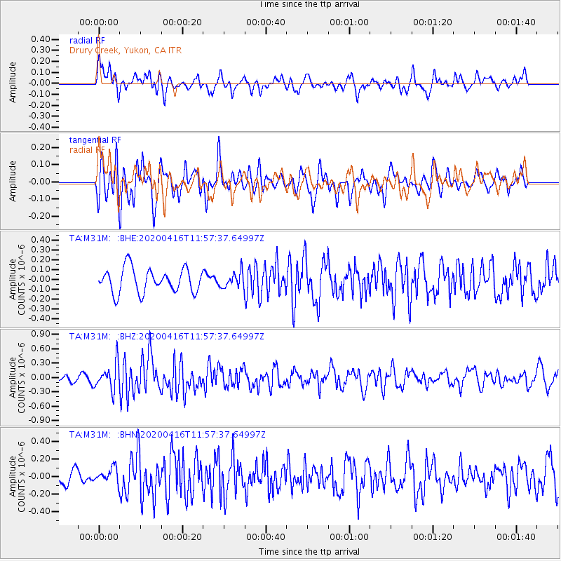
M31M Drury Creek, Yukon, CA - Earthquake Result Viewer
*The percent match for this event was below the threshold and hence no stack was calculated.
| Earthquake location: |
Myanmar |
| Earthquake latitude/longitude: |
22.8/94.0 |
| Earthquake time(UTC): |
2020/04/16 (107) 11:45:23 GMT |
| Earthquake Depth: |
10 km |
| Earthquake Magnitude: |
5.9 mww |
| Earthquake Catalog/Contributor: |
NEIC PDE/us |
|
| Network: |
TA USArray Transportable Network (new EarthScope stations) |
| Station: |
M31M Drury Creek, Yukon, CA |
| Lat/Lon: |
62.20 N/134.39 W |
| Elevation: |
639 m |
|
| Distance: |
87.0 deg |
| Az: |
20.557 deg |
| Baz: |
316.268 deg |
| Ray Param: |
$rayparam |
*The percent match for this event was below the threshold and hence was not used in the summary stack. |
|
| Radial Match: |
57.282898 % |
| Radial Bump: |
400 |
| Transverse Match: |
68.6841 % |
| Transverse Bump: |
400 |
| SOD ConfigId: |
21166931 |
| Insert Time: |
2020-04-30 11:57:30.999 +0000 |
| GWidth: |
2.5 |
| Max Bumps: |
400 |
| Tol: |
0.001 |
|
Signal To Noise
| Channel | StoN | STA | LTA |
| TA:M31M: :BHZ:20200416T11:57:37.64997Z | 3.531966 | 2.7760254E-7 | 7.8597175E-8 |
| TA:M31M: :BHN:20200416T11:57:37.64997Z | 1.4426771 | 9.104015E-8 | 6.3105E-8 |
| TA:M31M: :BHE:20200416T11:57:37.64997Z | 0.64631325 | 7.862227E-8 | 1.216473E-7 |
| Arrivals |
| Ps | |
| PpPs | |
| PsPs/PpSs | |


