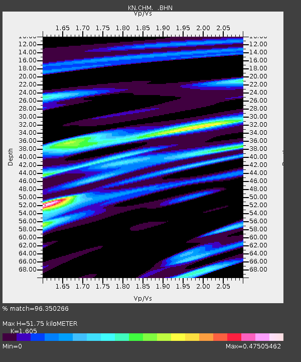
CHM KN.CHM - Earthquake Result Viewer
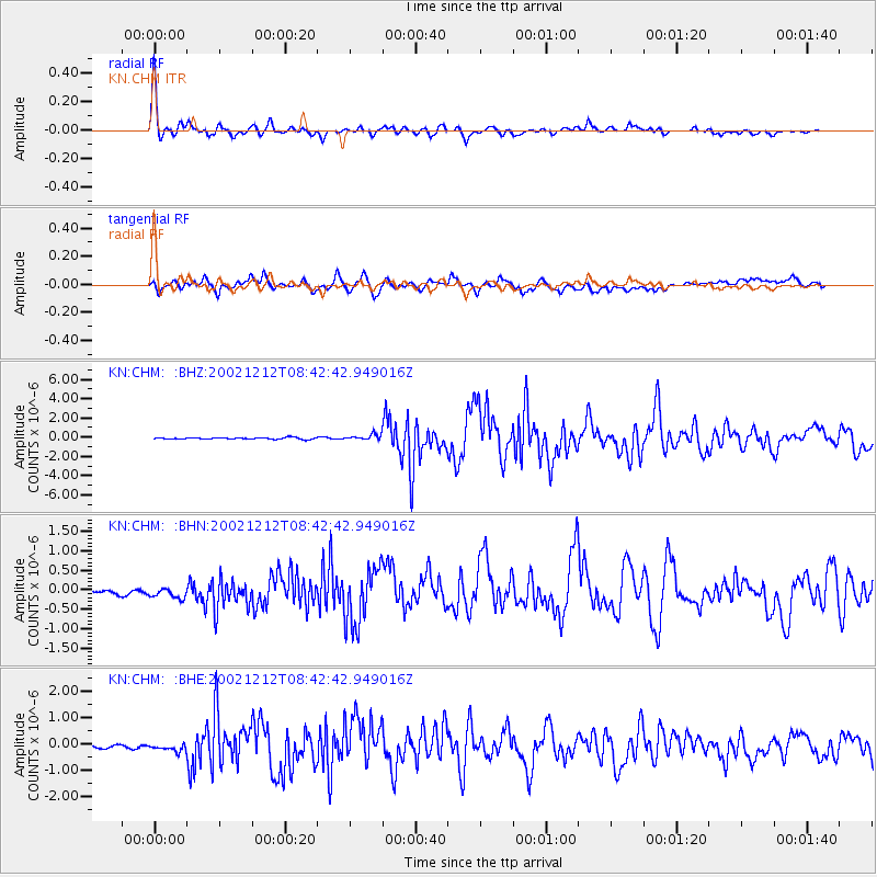
Earthquake location: New Ireland Region, P.N.G.
Earthquake latitude/longitude: -4.8/153.3
Earthquake time(UTC): 2002/12/12 (346) 08:30:42 GMT
Earthquake Depth: 34 km
Earthquake Magnitude: 5.9 MB, 6.7 MS, 6.7 MW, 6.6 MW
Earthquake Catalog/Contributor: WHDF/NEIC
Network: KN Kyrgyz Seismic Telemetry Network
Station: CHM KN.CHM
Lat/Lon: 43.00 N/74.75 E
Elevation: 655 m
Distance: 84.9 deg
Az: 313.792 deg
Baz: 101.322 deg
Ray Param: 0.045115873
Estimated Moho Depth: 51.75 km
Estimated Crust Vp/Vs: 1.61
Assumed Crust Vp: 6.306 km/s
Estimated Crust Vs: 3.929 km/s
Estimated Crust Poisson's Ratio: 0.18
Radial Match: 96.350266 %
Radial Bump: 330
Transverse Match: 80.803825 %
Transverse Bump: 400
SOD ConfigId: 4714
Insert Time: 2010-03-08 19:21:51.782 +0000
GWidth: 2.5
Max Bumps: 400
Tol: 0.001

Signal To Noise

ChannelStoNSTALTA
KN:CHM: :BHN:20021212T08:42:42.949016Z1.66494982.847391E-71.7101964E-7
KN:CHM: :BHE:20021212T08:42:42.949016Z2.5419551.7110925E-76.731403E-8
KN:CHM: :BHZ:20021212T08:42:42.949016Z3.67480042.9261216E-77.962667E-8
Arrivals
Ps5.1 SECOND
PpPs21 SECOND
PsPs/PpSs26 SECOND