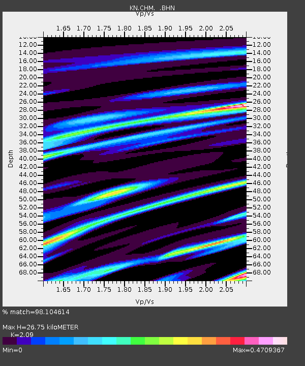
CHM KN.CHM - Earthquake Result Viewer
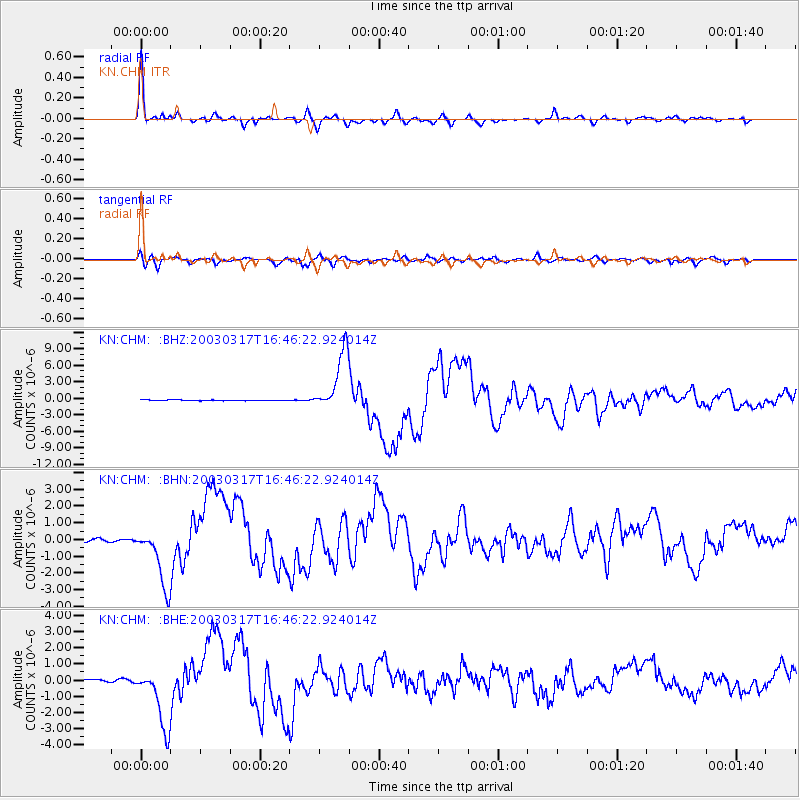
Earthquake location: Rat Islands, Aleutian Islands
Earthquake latitude/longitude: 51.3/178.0
Earthquake time(UTC): 2003/03/17 (076) 16:36:17 GMT
Earthquake Depth: 33 km
Earthquake Magnitude: 5.9 MB, 6.7 MS, 7.0 MW, 7.0 MW
Earthquake Catalog/Contributor: WHDF/NEIC
Network: KN Kyrgyz Seismic Telemetry Network
Station: CHM KN.CHM
Lat/Lon: 43.00 N/74.75 E
Elevation: 655 m
Distance: 65.0 deg
Az: 307.975 deg
Baz: 42.451 deg
Ray Param: 0.058533315
Estimated Moho Depth: 26.75 km
Estimated Crust Vp/Vs: 2.09
Assumed Crust Vp: 6.306 km/s
Estimated Crust Vs: 3.017 km/s
Estimated Crust Poisson's Ratio: 0.35
Radial Match: 98.104614 %
Radial Bump: 327
Transverse Match: 90.79477 %
Transverse Bump: 400
SOD ConfigId: 4714
Insert Time: 2010-03-08 19:22:12.342 +0000
GWidth: 2.5
Max Bumps: 400
Tol: 0.001

Signal To Noise

ChannelStoNSTALTA
KN:CHM: :BHN:20030317T16:46:22.924014Z16.6620581.8064641E-61.0841782E-7
KN:CHM: :BHE:20030317T16:46:22.924014Z26.2894211.9069207E-67.253567E-8
KN:CHM: :BHZ:20030317T16:46:22.924014Z71.651885.4361963E-67.586955E-8
Arrivals
Ps4.8 SECOND
PpPs13 SECOND
PsPs/PpSs17 SECOND