You are here: Home > Network List > US - United States National Seismic Network Stations List
> Station DGMT Dagmar, Montana, USA > Earthquake Result Viewer
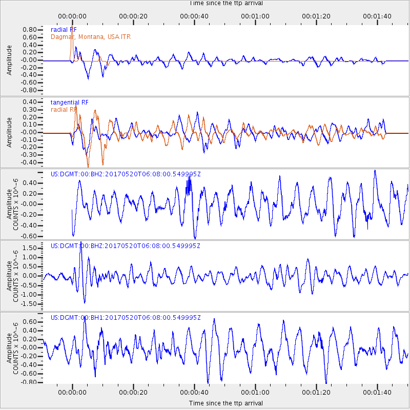
DGMT Dagmar, Montana, USA - Earthquake Result Viewer
*The percent match for this event was below the threshold and hence no stack was calculated.
| Earthquake location: |
Off Coast Of Jalisco, Mexico |
| Earthquake latitude/longitude: |
17.4/-105.4 |
| Earthquake time(UTC): |
2017/05/20 (140) 06:02:13 GMT |
| Earthquake Depth: |
10 km |
| Earthquake Magnitude: |
5.8 Mww |
| Earthquake Catalog/Contributor: |
NEIC PDE/us |
|
| Network: |
US United States National Seismic Network |
| Station: |
DGMT Dagmar, Montana, USA |
| Lat/Lon: |
48.47 N/104.20 W |
| Elevation: |
0.0 m |
|
| Distance: |
31.0 deg |
| Az: |
1.513 deg |
| Baz: |
182.171 deg |
| Ray Param: |
$rayparam |
*The percent match for this event was below the threshold and hence was not used in the summary stack. |
|
| Radial Match: |
71.5889 % |
| Radial Bump: |
336 |
| Transverse Match: |
54.531944 % |
| Transverse Bump: |
400 |
| SOD ConfigId: |
2028011 |
| Insert Time: |
2017-06-03 06:04:49.572 +0000 |
| GWidth: |
2.5 |
| Max Bumps: |
400 |
| Tol: |
0.001 |
|
Signal To Noise
| Channel | StoN | STA | LTA |
| US:DGMT:00:BHZ:20170520T06:08:00.549995Z | 6.2573414 | 7.847907E-7 | 1.2541919E-7 |
| US:DGMT:00:BH1:20170520T06:08:00.549995Z | 2.4210072 | 3.1041935E-7 | 1.2821909E-7 |
| US:DGMT:00:BH2:20170520T06:08:00.549995Z | 0.7141758 | 1.4179946E-7 | 1.985498E-7 |
| Arrivals |
| Ps | |
| PpPs | |
| PsPs/PpSs | |


