You are here: Home > Network List > TS - TERRAscope (Southern California Seismic Network) Stations List
> Station SBC Santa Barbara, California, USA > Earthquake Result Viewer
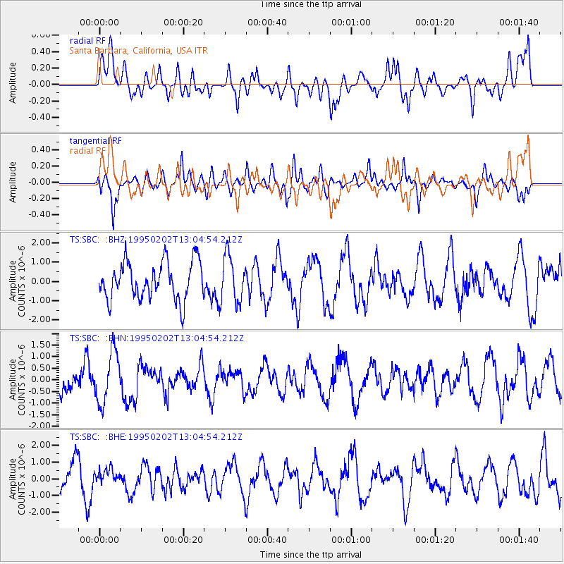
SBC Santa Barbara, California, USA - Earthquake Result Viewer
*The percent match for this event was below the threshold and hence no stack was calculated.
| Earthquake location: |
Northern Mid-Atlantic Ridge |
| Earthquake latitude/longitude: |
10.8/-42.6 |
| Earthquake time(UTC): |
1995/02/02 (033) 12:53:53 GMT |
| Earthquake Depth: |
10 km |
| Earthquake Magnitude: |
5.6 MB, 5.4 MS, 5.8 UNKNOWN |
| Earthquake Catalog/Contributor: |
WHDF/NEIC |
|
| Network: |
TS TERRAscope (Southern California Seismic Network) |
| Station: |
SBC Santa Barbara, California, USA |
| Lat/Lon: |
34.44 N/119.71 W |
| Elevation: |
90 m |
|
| Distance: |
73.4 deg |
| Az: |
302.793 deg |
| Baz: |
88.191 deg |
| Ray Param: |
$rayparam |
*The percent match for this event was below the threshold and hence was not used in the summary stack. |
|
| Radial Match: |
57.04415 % |
| Radial Bump: |
400 |
| Transverse Match: |
57.758736 % |
| Transverse Bump: |
400 |
| SOD ConfigId: |
4480 |
| Insert Time: |
2010-02-26 14:47:34.152 +0000 |
| GWidth: |
2.5 |
| Max Bumps: |
400 |
| Tol: |
0.001 |
|
Signal To Noise
| Channel | StoN | STA | LTA |
| TS:SBC: :BHN:19950202T13:04:54.212Z | 2.4473648 | 1.122789E-6 | 4.5877465E-7 |
| TS:SBC: :BHE:19950202T13:04:54.212Z | 0.39844656 | 4.5573648E-7 | 1.1437832E-6 |
| TS:SBC: :BHZ:19950202T13:04:54.212Z | 1.2089704 | 1.1794741E-6 | 9.756021E-7 |
| Arrivals |
| Ps | |
| PpPs | |
| PsPs/PpSs | |


