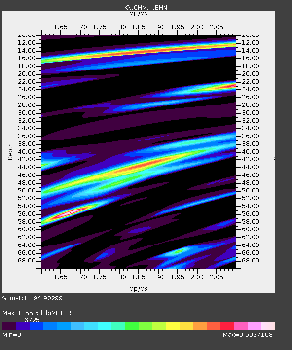
CHM KN.CHM - Earthquake Result Viewer
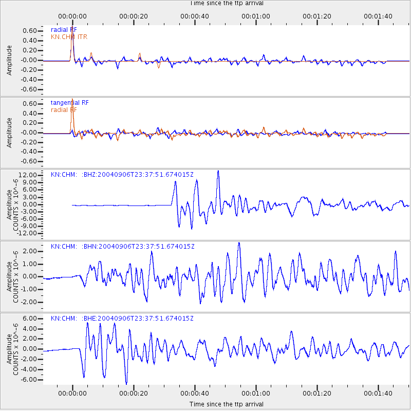
Earthquake location: Near S. Coast Of Honshu, Japan
Earthquake latitude/longitude: 33.2/137.2
Earthquake time(UTC): 2004/09/06 (250) 23:29:35 GMT
Earthquake Depth: 10 km
Earthquake Magnitude: 6.4 MB, 6.3 MS, 6.7 MW, 6.5 MW
Earthquake Catalog/Contributor: WHDF/NEIC
Network: KN Kyrgyz Seismic Telemetry Network
Station: CHM KN.CHM
Lat/Lon: 43.00 N/74.75 E
Elevation: 655 m
Distance: 49.1 deg
Az: 300.609 deg
Baz: 79.589 deg
Ray Param: 0.06891396
Estimated Moho Depth: 55.5 km
Estimated Crust Vp/Vs: 1.67
Assumed Crust Vp: 6.306 km/s
Estimated Crust Vs: 3.77 km/s
Estimated Crust Poisson's Ratio: 0.22
Radial Match: 94.90299 %
Radial Bump: 334
Transverse Match: 83.95069 %
Transverse Bump: 400
SOD ConfigId: 2459
Insert Time: 2010-03-08 19:22:52.759 +0000
GWidth: 2.5
Max Bumps: 400
Tol: 0.001

Signal To Noise

ChannelStoNSTALTA
KN:CHM: :BHN:20040906T23:37:51.674015Z2.12706162.7159788E-71.276869E-7
KN:CHM: :BHE:20040906T23:37:51.674015Z14.5045282.2528777E-61.5532235E-7
KN:CHM: :BHZ:20040906T23:37:51.674015Z55.3076444.108198E-67.427903E-8
Arrivals
Ps6.3 SECOND
PpPs22 SECOND
PsPs/PpSs28 SECOND