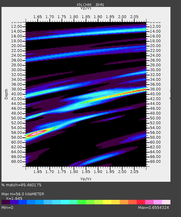
CHM KN.CHM - Earthquake Result Viewer
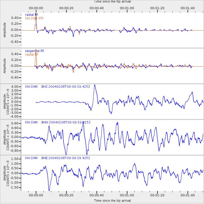
Earthquake location: Irian Jaya Region, Indonesia
Earthquake latitude/longitude: -3.7/135.3
Earthquake time(UTC): 2004/02/08 (039) 08:58:51 GMT
Earthquake Depth: 26 km
Earthquake Magnitude: 5.7 MB, 6.9 MS, 6.7 MW, 6.5 MW
Earthquake Catalog/Contributor: WHDF/NEIC
Network: KN Kyrgyz Seismic Telemetry Network
Station: CHM KN.CHM
Lat/Lon: 43.00 N/74.75 E
Elevation: 655 m
Distance: 71.6 deg
Az: 317.646 deg
Baz: 113.589 deg
Ray Param: 0.054217894
Estimated Moho Depth: 56.0 km
Estimated Crust Vp/Vs: 1.64
Assumed Crust Vp: 6.306 km/s
Estimated Crust Vs: 3.833 km/s
Estimated Crust Poisson's Ratio: 0.21
Radial Match: 95.460175 %
Radial Bump: 304
Transverse Match: 83.4674 %
Transverse Bump: 400
SOD ConfigId: 2459
Insert Time: 2010-03-08 19:23:16.309 +0000
GWidth: 2.5
Max Bumps: 400
Tol: 0.001

Signal To Noise

ChannelStoNSTALTA
KN:CHM: :BHN:20040208T09:09:39.425Z1.17612294.8369103E-84.112589E-8
KN:CHM: :BHE:20040208T09:09:39.425Z3.68522832.2770418E-76.178835E-8
KN:CHM: :BHZ:20040208T09:09:39.425Z4.96741774.0572857E-78.167797E-8
Arrivals
Ps5.9 SECOND
PpPs23 SECOND
PsPs/PpSs29 SECOND