You are here: Home > Network List > AK - Alaska Regional Network Stations List
> Station SLK Skilak Lake, AK, USA > Earthquake Result Viewer
SLK Skilak Lake, AK, USA - Earthquake Result Viewer
| Earthquake location: |
Bonin Islands, Japan Region |
| Earthquake latitude/longitude: |
27.1/140.1 |
| Earthquake time(UTC): |
2020/04/18 (109) 08:25:37 GMT |
| Earthquake Depth: |
454 km |
| Earthquake Magnitude: |
6.6 Mww |
| Earthquake Catalog/Contributor: |
NEIC PDE/us |
|
| Network: |
AK Alaska Regional Network |
| Station: |
SLK Skilak Lake, AK, USA |
| Lat/Lon: |
60.51 N/150.22 W |
| Elevation: |
655 m |
|
| Distance: |
56.8 deg |
| Az: |
33.67 deg |
| Baz: |
266.948 deg |
| Ray Param: |
0.062146056 |
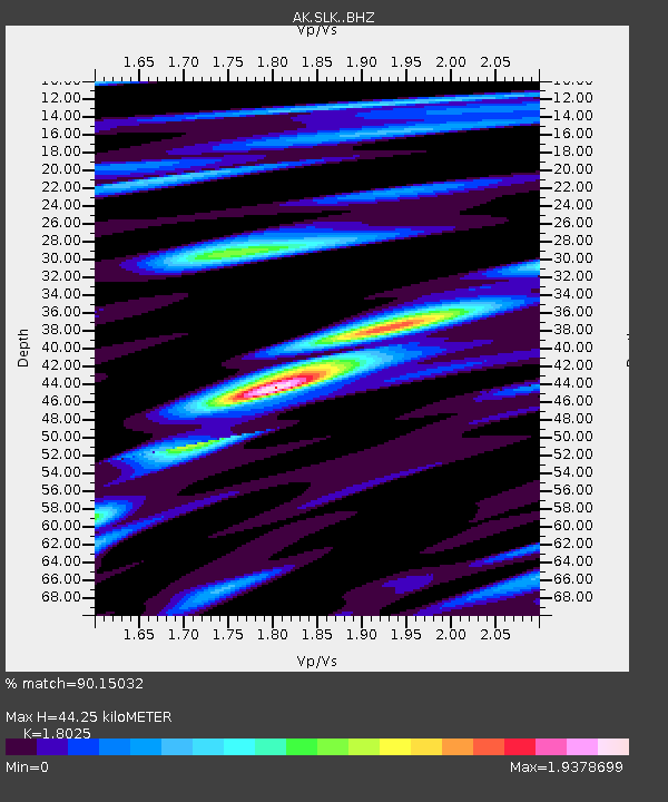
| Estimated Moho Depth: |
44.25 km |
| Estimated Crust Vp/Vs: |
1.80 |
| Assumed Crust Vp: |
6.302 km/s |
| Estimated Crust Vs: |
3.496 km/s |
| Estimated Crust Poisson's Ratio: |
0.28 |
|
| Radial Match: |
90.15032 % |
| Radial Bump: |
400 |
| Transverse Match: |
79.48633 % |
| Transverse Bump: |
400 |
| SOD ConfigId: |
21166931 |
| Insert Time: |
2020-05-02 08:29:04.043 +0000 |
| GWidth: |
2.5 |
| Max Bumps: |
400 |
| Tol: |
0.001 |
|

Signal To Noise
| Channel | StoN | STA | LTA |
| AK:SLK: :BHZ:20200418T08:34:06.247997Z | 21.284977 | 2.9711007E-6 | 1.3958675E-7 |
| AK:SLK: :BHN:20200418T08:34:06.247997Z | 6.1319594 | 4.8003614E-7 | 7.82843E-8 |
| AK:SLK: :BHE:20200418T08:34:06.247997Z | 20.07868 | 2.3075702E-6 | 1.14926394E-7 |
| Arrivals |
| Ps | 5.9 SECOND |
| PpPs | 19 SECOND |
| PsPs/PpSs | 25 SECOND |


