You are here: Home > Network List > TS - TERRAscope (Southern California Seismic Network) Stations List
> Station SBC Santa Barbara, California, USA > Earthquake Result Viewer
SBC Santa Barbara, California, USA - Earthquake Result Viewer
*The percent match for this event was below the threshold and hence no stack was calculated.
| Earthquake location: |
Windward Islands |
| Earthquake latitude/longitude: |
11.4/-60.9 |
| Earthquake time(UTC): |
1997/04/02 (092) 06:14:31 GMT |
| Earthquake Depth: |
45 km |
| Earthquake Magnitude: |
5.8 MB, 5.5 MS, 6.2 UNKNOWN, 5.6 MD |
| Earthquake Catalog/Contributor: |
WHDF/NEIC |
|
| Network: |
TS TERRAscope (Southern California Seismic Network) |
| Station: |
SBC Santa Barbara, California, USA |
| Lat/Lon: |
34.44 N/119.71 W |
| Elevation: |
90 m |
|
| Distance: |
57.9 deg |
| Az: |
303.5 deg |
| Baz: |
98.394 deg |
| Ray Param: |
$rayparam |
*The percent match for this event was below the threshold and hence was not used in the summary stack. |
|
| Radial Match: |
63.487415 % |
| Radial Bump: |
400 |
| Transverse Match: |
57.11179 % |
| Transverse Bump: |
400 |
| SOD ConfigId: |
4480 |
| Insert Time: |
2010-02-26 14:47:41.388 +0000 |
| GWidth: |
2.5 |
| Max Bumps: |
400 |
| Tol: |
0.001 |
|
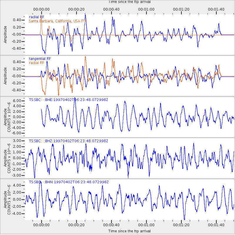
Signal To Noise
| Channel | StoN | STA | LTA |
| TS:SBC: :BHZ:19970402T06:23:48.072998Z | 0.88801414 | 1.2724112E-6 | 1.4328726E-6 |
| TS:SBC: :BHN:19970402T06:23:48.072998Z | 2.5851018 | 2.9968635E-6 | 1.1592825E-6 |
| TS:SBC: :BHE:19970402T06:23:48.072998Z | 1.1953738 | 3.2365697E-6 | 2.7075796E-6 |
| Arrivals |
| Ps | |
| PpPs | |
| PsPs/PpSs | |


