You are here: Home > Network List > AV - Alaska Volcano Observatory Stations List
> Station TANO North, Tanaga Volcano, Alaska > Earthquake Result Viewer
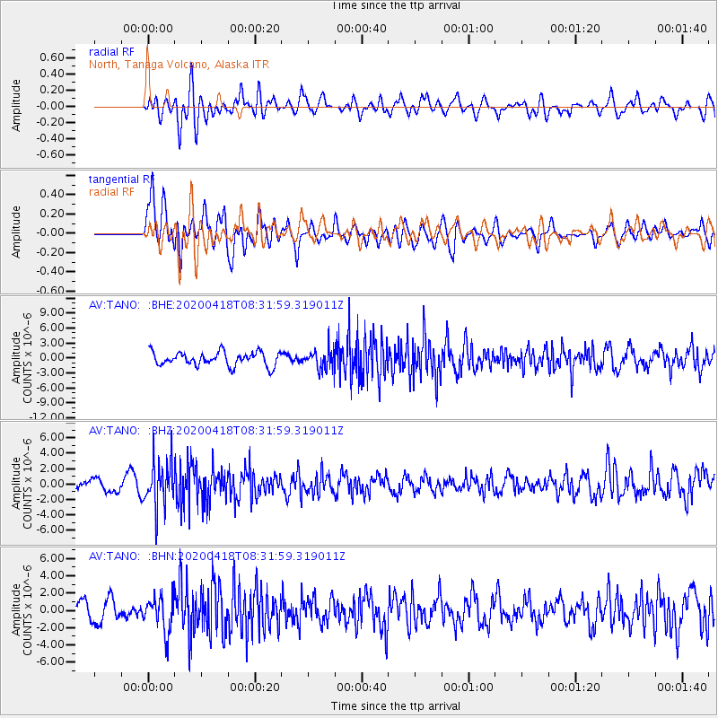
TANO North, Tanaga Volcano, Alaska - Earthquake Result Viewer
*The percent match for this event was below the threshold and hence no stack was calculated.
| Earthquake location: |
Bonin Islands, Japan Region |
| Earthquake latitude/longitude: |
27.1/140.1 |
| Earthquake time(UTC): |
2020/04/18 (109) 08:25:37 GMT |
| Earthquake Depth: |
454 km |
| Earthquake Magnitude: |
6.6 Mww |
| Earthquake Catalog/Contributor: |
NEIC PDE/us |
|
| Network: |
AV Alaska Volcano Observatory |
| Station: |
TANO North, Tanaga Volcano, Alaska |
| Lat/Lon: |
51.91 N/178.12 W |
| Elevation: |
269 m |
|
| Distance: |
39.8 deg |
| Az: |
40.1 deg |
| Baz: |
247.927 deg |
| Ray Param: |
$rayparam |
*The percent match for this event was below the threshold and hence was not used in the summary stack. |
|
| Radial Match: |
56.62589 % |
| Radial Bump: |
400 |
| Transverse Match: |
60.87514 % |
| Transverse Bump: |
400 |
| SOD ConfigId: |
21166931 |
| Insert Time: |
2020-05-02 08:32:24.477 +0000 |
| GWidth: |
2.5 |
| Max Bumps: |
400 |
| Tol: |
0.001 |
|
Signal To Noise
| Channel | StoN | STA | LTA |
| AV:TANO: :BHZ:20200418T08:31:59.319011Z | 4.8166103 | 2.966733E-6 | 6.1593795E-7 |
| AV:TANO: :BHN:20200418T08:31:59.319011Z | 1.5461203 | 2.0684265E-6 | 1.3378174E-6 |
| AV:TANO: :BHE:20200418T08:31:59.319011Z | 1.4393233 | 1.9923991E-6 | 1.3842609E-6 |
| Arrivals |
| Ps | |
| PpPs | |
| PsPs/PpSs | |


