You are here: Home > Network List > CC - Cascade Chain Volcano Monitoring Stations List
> Station TIMB Timberline, OR > Earthquake Result Viewer
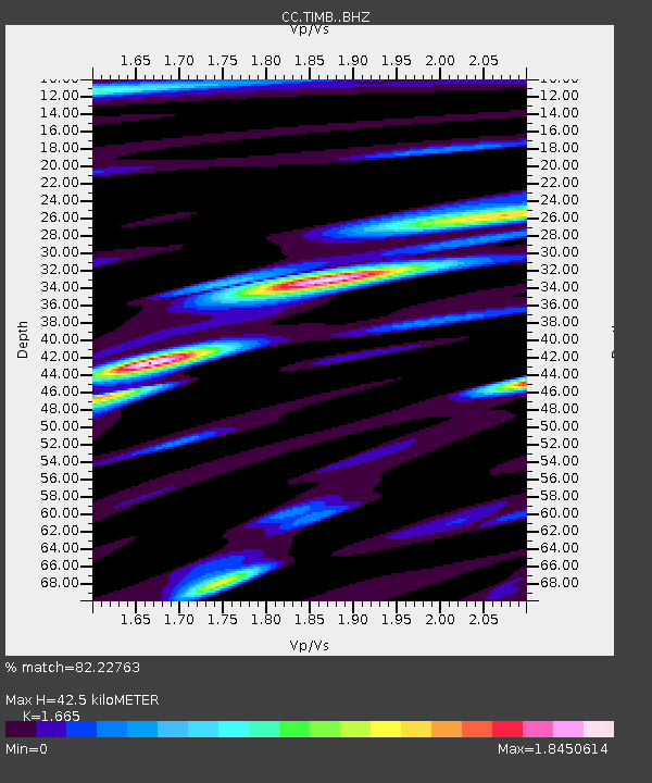
TIMB Timberline, OR - Earthquake Result Viewer
| Earthquake location: |
Bonin Islands, Japan Region |
| Earthquake latitude/longitude: |
27.1/140.1 |
| Earthquake time(UTC): |
2020/04/18 (109) 08:25:37 GMT |
| Earthquake Depth: |
454 km |
| Earthquake Magnitude: |
6.6 Mww |
| Earthquake Catalog/Contributor: |
NEIC PDE/us |
|
| Network: |
CC Cascade Chain Volcano Monitoring |
| Station: |
TIMB Timberline, OR |
| Lat/Lon: |
45.34 N/121.71 W |
| Elevation: |
1869 m |
|
| Distance: |
76.6 deg |
| Az: |
45.87 deg |
| Baz: |
294.928 deg |
| Ray Param: |
0.049551032 |
| Estimated Moho Depth: |
42.5 km |
| Estimated Crust Vp/Vs: |
1.66 |
| Assumed Crust Vp: |
6.597 km/s |
| Estimated Crust Vs: |
3.962 km/s |
| Estimated Crust Poisson's Ratio: |
0.22 |
|
| Radial Match: |
82.22763 % |
| Radial Bump: |
400 |
| Transverse Match: |
84.92926 % |
| Transverse Bump: |
400 |
| SOD ConfigId: |
21166931 |
| Insert Time: |
2020-05-02 08:34:20.916 +0000 |
| GWidth: |
2.5 |
| Max Bumps: |
400 |
| Tol: |
0.001 |
|

Signal To Noise
| Channel | StoN | STA | LTA |
| CC:TIMB: :BHZ:20200418T08:36:08.719982Z | 17.253485 | 2.5725687E-6 | 1.491043E-7 |
| CC:TIMB: :BHN:20200418T08:36:08.719982Z | 2.9792135 | 8.322364E-7 | 2.793477E-7 |
| CC:TIMB: :BHE:20200418T08:36:08.719982Z | 3.985524 | 1.171032E-6 | 2.9382136E-7 |
| Arrivals |
| Ps | 4.4 SECOND |
| PpPs | 17 SECOND |
| PsPs/PpSs | 21 SECOND |


