You are here: Home > Network List > CN - Canadian National Seismograph Network Stations List
> Station WPB Watts Point, BC, CA > Earthquake Result Viewer
WPB Watts Point, BC, CA - Earthquake Result Viewer
| Earthquake location: |
Bonin Islands, Japan Region |
| Earthquake latitude/longitude: |
27.1/140.1 |
| Earthquake time(UTC): |
2020/04/18 (109) 08:25:37 GMT |
| Earthquake Depth: |
454 km |
| Earthquake Magnitude: |
6.6 Mww |
| Earthquake Catalog/Contributor: |
NEIC PDE/us |
|
| Network: |
CN Canadian National Seismograph Network |
| Station: |
WPB Watts Point, BC, CA |
| Lat/Lon: |
49.65 N/123.21 W |
| Elevation: |
260 m |
|
| Distance: |
73.9 deg |
| Az: |
42.218 deg |
| Baz: |
292.894 deg |
| Ray Param: |
0.051305775 |
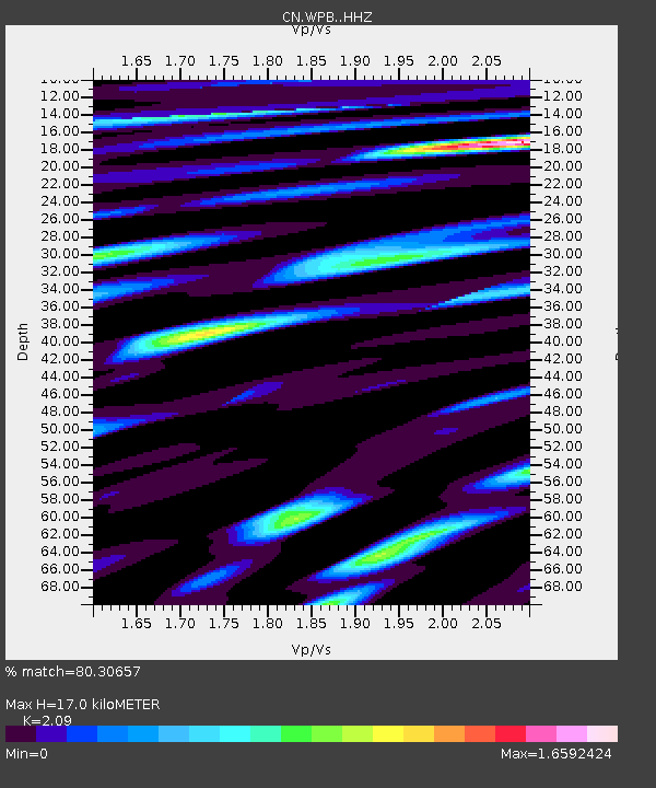
| Estimated Moho Depth: |
17.0 km |
| Estimated Crust Vp/Vs: |
2.09 |
| Assumed Crust Vp: |
6.566 km/s |
| Estimated Crust Vs: |
3.142 km/s |
| Estimated Crust Poisson's Ratio: |
0.35 |
|
| Radial Match: |
80.30657 % |
| Radial Bump: |
400 |
| Transverse Match: |
80.674576 % |
| Transverse Bump: |
400 |
| SOD ConfigId: |
21166931 |
| Insert Time: |
2020-05-02 08:38:11.866 +0000 |
| GWidth: |
2.5 |
| Max Bumps: |
400 |
| Tol: |
0.001 |
|

Signal To Noise
| Channel | StoN | STA | LTA |
| CN:WPB: :HHZ:20200418T08:35:53.740001Z | 10.474375 | 1.7348433E-6 | 1.6562738E-7 |
| CN:WPB: :HHN:20200418T08:35:53.740001Z | 2.1830237 | 2.8260055E-7 | 1.2945372E-7 |
| CN:WPB: :HHE:20200418T08:35:53.740001Z | 6.552534 | 6.6218854E-7 | 1.0105839E-7 |
| Arrivals |
| Ps | 2.9 SECOND |
| PpPs | 7.8 SECOND |
| PsPs/PpSs | 11 SECOND |


