You are here: Home > Network List > US - United States National Seismic Network Stations List
> Station MSO Missoula, Montana, USA > Earthquake Result Viewer
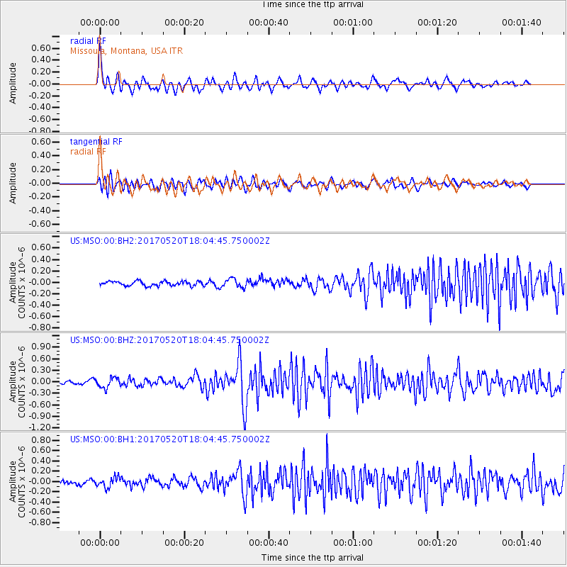
MSO Missoula, Montana, USA - Earthquake Result Viewer
*The percent match for this event was below the threshold and hence no stack was calculated.
| Earthquake location: |
Chiapas, Mexico |
| Earthquake latitude/longitude: |
17.1/-94.0 |
| Earthquake time(UTC): |
2017/05/20 (140) 17:58:46 GMT |
| Earthquake Depth: |
144 km |
| Earthquake Magnitude: |
5.7 Mww |
| Earthquake Catalog/Contributor: |
NEIC PDE/us |
|
| Network: |
US United States National Seismic Network |
| Station: |
MSO Missoula, Montana, USA |
| Lat/Lon: |
46.83 N/113.94 W |
| Elevation: |
1264 m |
|
| Distance: |
33.9 deg |
| Az: |
335.176 deg |
| Baz: |
144.219 deg |
| Ray Param: |
$rayparam |
*The percent match for this event was below the threshold and hence was not used in the summary stack. |
|
| Radial Match: |
73.44573 % |
| Radial Bump: |
400 |
| Transverse Match: |
67.88257 % |
| Transverse Bump: |
400 |
| SOD ConfigId: |
2028011 |
| Insert Time: |
2017-06-03 18:03:14.858 +0000 |
| GWidth: |
2.5 |
| Max Bumps: |
400 |
| Tol: |
0.001 |
|
Signal To Noise
| Channel | StoN | STA | LTA |
| US:MSO:00:BHZ:20170520T18:04:45.750002Z | 1.9006037 | 1.311148E-7 | 6.898587E-8 |
| US:MSO:00:BH1:20170520T18:04:45.750002Z | 2.3928404 | 9.956893E-8 | 4.1611187E-8 |
| US:MSO:00:BH2:20170520T18:04:45.750002Z | 1.9402819 | 7.507852E-8 | 3.8694644E-8 |
| Arrivals |
| Ps | |
| PpPs | |
| PsPs/PpSs | |


