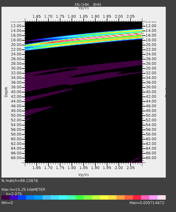
CHM KN.CHM - Earthquake Result Viewer

Earthquake location: Svalbard Region
Earthquake latitude/longitude: 77.1/18.6
Earthquake time(UTC): 2008/02/21 (052) 02:46:17 GMT
Earthquake Depth: 10 km
Earthquake Magnitude: 5.7 MB, 5.9 MS, 6.1 MW, 6.0 MW
Earthquake Catalog/Contributor: WHDF/NEIC
Network: KN Kyrgyz Seismic Telemetry Network
Station: CHM KN.CHM
Lat/Lon: 43.00 N/74.75 E
Elevation: 655 m
Distance: 41.1 deg
Az: 111.897 deg
Baz: 343.466 deg
Ray Param: 0.0740265
Estimated Moho Depth: 15.25 km
Estimated Crust Vp/Vs: 2.08
Assumed Crust Vp: 6.306 km/s
Estimated Crust Vs: 3.039 km/s
Estimated Crust Poisson's Ratio: 0.35
Radial Match: 99.10676 %
Radial Bump: 29
Transverse Match: 42.527176 %
Transverse Bump: 360
SOD ConfigId: 2564
Insert Time: 2010-03-08 19:25:11.013 +0000
GWidth: 2.5
Max Bumps: 400
Tol: 0.001

Signal To Noise

ChannelStoNSTALTA
KN:CHM: :BHN:20080221T02:53:30.623011Z0.97986375.0035686E-75.106392E-7
KN:CHM: :BHE:20080221T02:53:30.623011Z1.27007917.480086E-85.889465E-8
KN:CHM: :BHZ:20080221T02:53:30.623011Z6.62598754.2484734E-76.411834E-8
Arrivals
Ps2.8 SECOND
PpPs7.0 SECOND
PsPs/PpSs9.8 SECOND