You are here: Home > Network List > KN - Kyrgyz Seismic Telemetry Network Stations List
> Station CHM KN.CHM > Earthquake Result Viewer
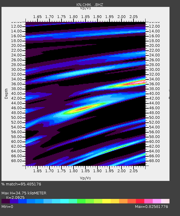
CHM KN.CHM - Earthquake Result Viewer
| Earthquake location: |
Off East Coast Of Honshu, Japan |
| Earthquake latitude/longitude: |
39.5/143.0 |
| Earthquake time(UTC): |
1992/07/18 (200) 13:56:53 GMT |
| Earthquake Depth: |
21 km |
| Earthquake Magnitude: |
5.7 MB, 6.0 MS |
| Earthquake Catalog/Contributor: |
WHDF/NEIC |
|
| Network: |
KN Kyrgyz Seismic Telemetry Network |
| Station: |
CHM KN.CHM |
| Lat/Lon: |
43.00 N/74.75 E |
| Elevation: |
655 m |
|
| Distance: |
50.2 deg |
| Az: |
297.454 deg |
| Baz: |
69.438 deg |
| Ray Param: |
0.068201974 |
| Estimated Moho Depth: |
34.75 km |
| Estimated Crust Vp/Vs: |
2.09 |
| Assumed Crust Vp: |
6.306 km/s |
| Estimated Crust Vs: |
3.014 km/s |
| Estimated Crust Poisson's Ratio: |
0.35 |
|
| Radial Match: |
95.485176 % |
| Radial Bump: |
356 |
| Transverse Match: |
90.82321 % |
| Transverse Bump: |
400 |
| SOD ConfigId: |
4480 |
| Insert Time: |
2010-03-08 19:25:25.441 +0000 |
| GWidth: |
2.5 |
| Max Bumps: |
400 |
| Tol: |
0.001 |
|

Signal To Noise
| Channel | StoN | STA | LTA |
| KN:CHM: :BHZ:19920718T14:05:16.748987Z | 30.488928 | 1.1702999E-6 | 3.8384425E-8 |
| KN:CHM: :BHN:19920718T14:05:16.748987Z | 4.0015373 | 1.3897039E-7 | 3.472925E-8 |
| KN:CHM: :BHE:19920718T14:05:16.748987Z | 14.9803095 | 6.0702484E-7 | 4.0521513E-8 |
| Arrivals |
| Ps | 6.3 SECOND |
| PpPs | 16 SECOND |
| PsPs/PpSs | 23 SECOND |


