You are here: Home > Network List > KN - Kyrgyz Seismic Telemetry Network Stations List
> Station CHM KN.CHM > Earthquake Result Viewer
CHM KN.CHM - Earthquake Result Viewer
| Earthquake location: |
Svalbard Region |
| Earthquake latitude/longitude: |
78.5/5.1 |
| Earthquake time(UTC): |
1992/07/20 (202) 07:46:46 GMT |
| Earthquake Depth: |
10 km |
| Earthquake Magnitude: |
5.8 MB, 6.3 MS |
| Earthquake Catalog/Contributor: |
WHDF/NEIC |
|
| Network: |
KN Kyrgyz Seismic Telemetry Network |
| Station: |
CHM KN.CHM |
| Lat/Lon: |
43.00 N/74.75 E |
| Elevation: |
655 m |
|
| Distance: |
44.2 deg |
| Az: |
99.296 deg |
| Baz: |
344.297 deg |
| Ray Param: |
0.07205995 |
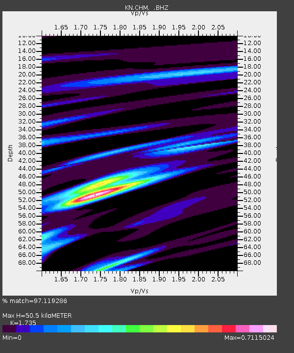
| Estimated Moho Depth: |
50.5 km |
| Estimated Crust Vp/Vs: |
1.74 |
| Assumed Crust Vp: |
6.306 km/s |
| Estimated Crust Vs: |
3.635 km/s |
| Estimated Crust Poisson's Ratio: |
0.25 |
|
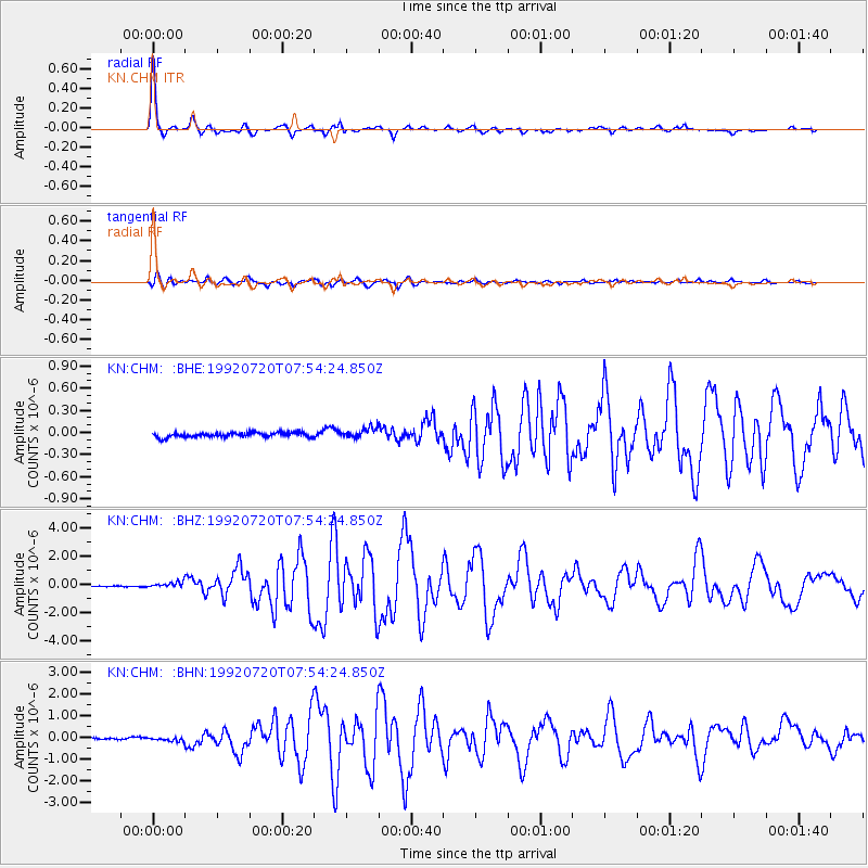
| Radial Match: |
97.119286 % |
| Radial Bump: |
289 |
| Transverse Match: |
94.14555 % |
| Transverse Bump: |
400 |
| SOD ConfigId: |
4480 |
| Insert Time: |
2010-03-08 19:25:26.565 +0000 |
| GWidth: |
2.5 |
| Max Bumps: |
400 |
| Tol: |
0.001 |
|
Signal To Noise
| Channel | StoN | STA | LTA |
| KN:CHM: :BHZ:19920720T07:54:24.850Z | 4.6693373 | 2.0691475E-7 | 4.4313516E-8 |
| KN:CHM: :BHN:19920720T07:54:24.850Z | 2.4113905 | 9.913795E-8 | 4.1112354E-8 |
| KN:CHM: :BHE:19920720T07:54:24.850Z | 2.246051 | 6.908207E-8 | 3.075712E-8 |
| Arrivals |
| Ps | 6.3 SECOND |
| PpPs | 21 SECOND |
| PsPs/PpSs | 27 SECOND |


