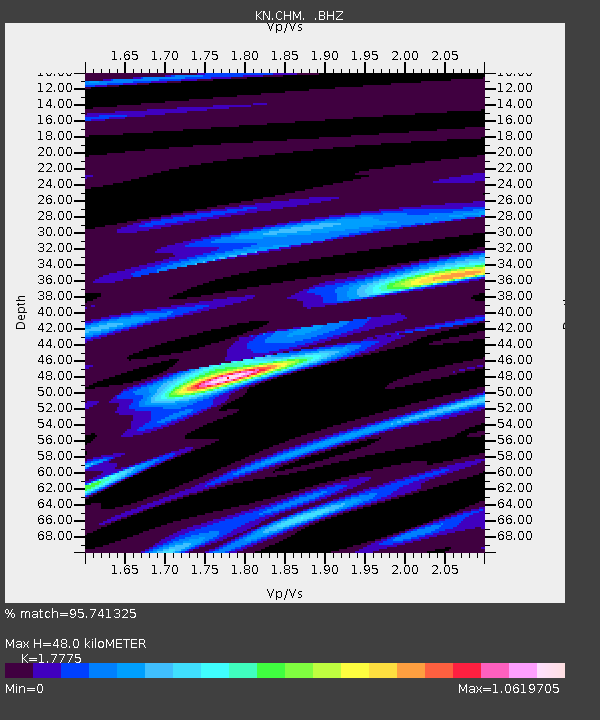
CHM KN.CHM - Earthquake Result Viewer

Earthquake location: Off East Coast Of Honshu, Japan
Earthquake latitude/longitude: 38.6/143.0
Earthquake time(UTC): 1992/07/25 (207) 02:53:29 GMT
Earthquake Depth: 29 km
Earthquake Magnitude: 5.9 MB, 5.6 MS, 5.4 UNKNOWN
Earthquake Catalog/Contributor: WHDF/NEIC
Network: KN Kyrgyz Seismic Telemetry Network
Station: CHM KN.CHM
Lat/Lon: 43.00 N/74.75 E
Elevation: 655 m
Distance: 50.6 deg
Az: 298.051 deg
Baz: 70.38 deg
Ray Param: 0.06792612
Estimated Moho Depth: 48.0 km
Estimated Crust Vp/Vs: 1.78
Assumed Crust Vp: 6.306 km/s
Estimated Crust Vs: 3.548 km/s
Estimated Crust Poisson's Ratio: 0.27
Radial Match: 95.741325 %
Radial Bump: 336
Transverse Match: 82.81615 %
Transverse Bump: 400
SOD ConfigId: 4480
Insert Time: 2010-03-08 19:25:27.706 +0000
GWidth: 2.5
Max Bumps: 400
Tol: 0.001

Signal To Noise

ChannelStoNSTALTA
KN:CHM: :BHZ:19920725T03:01:54.800006Z26.2461851.0706411E-64.0792255E-8
KN:CHM: :BHN:19920725T03:01:54.800006Z4.02489471.2647048E-73.142206E-8
KN:CHM: :BHE:19920725T03:01:54.800006Z13.7986735.6865974E-74.1211187E-8
Arrivals
Ps6.3 SECOND
PpPs20 SECOND
PsPs/PpSs26 SECOND