You are here: Home > Network List > IU - Global Seismograph Network (GSN - IRIS/USGS) Stations List
> Station BILL Bilibino, Russia > Earthquake Result Viewer
BILL Bilibino, Russia - Earthquake Result Viewer
| Earthquake location: |
Bonin Islands, Japan Region |
| Earthquake latitude/longitude: |
27.1/140.1 |
| Earthquake time(UTC): |
2020/04/18 (109) 08:25:37 GMT |
| Earthquake Depth: |
454 km |
| Earthquake Magnitude: |
6.6 Mww |
| Earthquake Catalog/Contributor: |
NEIC PDE/us |
|
| Network: |
IU Global Seismograph Network (GSN - IRIS/USGS) |
| Station: |
BILL Bilibino, Russia |
| Lat/Lon: |
68.07 N/166.45 E |
| Elevation: |
320 m |
|
| Distance: |
43.9 deg |
| Az: |
13.914 deg |
| Baz: |
214.774 deg |
| Ray Param: |
0.07018212 |
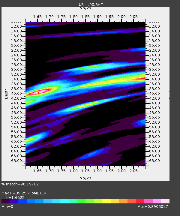
| Estimated Moho Depth: |
39.25 km |
| Estimated Crust Vp/Vs: |
1.65 |
| Assumed Crust Vp: |
6.577 km/s |
| Estimated Crust Vs: |
3.98 km/s |
| Estimated Crust Poisson's Ratio: |
0.21 |
|
| Radial Match: |
96.19782 % |
| Radial Bump: |
400 |
| Transverse Match: |
93.19742 % |
| Transverse Bump: |
400 |
| SOD ConfigId: |
21166931 |
| Insert Time: |
2020-05-02 08:41:37.434 +0000 |
| GWidth: |
2.5 |
| Max Bumps: |
400 |
| Tol: |
0.001 |
|
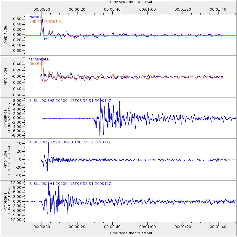
Signal To Noise
| Channel | StoN | STA | LTA |
| IU:BILL:00:BHZ:20200418T08:32:31.569011Z | 106.651505 | 1.396815E-5 | 1.3097002E-7 |
| IU:BILL:00:BH1:20200418T08:32:31.569011Z | 22.797304 | 4.7713143E-6 | 2.0929292E-7 |
| IU:BILL:00:BH2:20200418T08:32:31.569011Z | 48.81366 | 3.2439088E-6 | 6.645494E-8 |
| Arrivals |
| Ps | 4.2 SECOND |
| PpPs | 15 SECOND |
| PsPs/PpSs | 19 SECOND |


