You are here: Home > Network List > KN - Kyrgyz Seismic Telemetry Network Stations List
> Station CHM KN.CHM > Earthquake Result Viewer
CHM KN.CHM - Earthquake Result Viewer
| Earthquake location: |
Halmahera, Indonesia |
| Earthquake latitude/longitude: |
-0.9/127.6 |
| Earthquake time(UTC): |
1992/08/02 (215) 05:50:13 GMT |
| Earthquake Depth: |
33 km |
| Earthquake Magnitude: |
5.8 MB, 6.2 MS, 6.6 UNKNOWN |
| Earthquake Catalog/Contributor: |
WHDF/NEIC |
|
| Network: |
KN Kyrgyz Seismic Telemetry Network |
| Station: |
CHM KN.CHM |
| Lat/Lon: |
43.00 N/74.75 E |
| Elevation: |
655 m |
|
| Distance: |
64.4 deg |
| Az: |
319.573 deg |
| Baz: |
117.897 deg |
| Ray Param: |
0.05891228 |
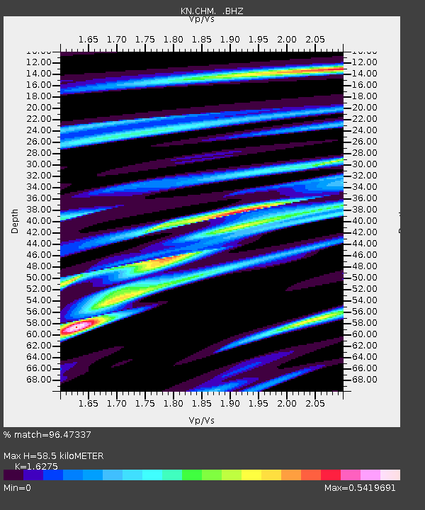
| Estimated Moho Depth: |
58.5 km |
| Estimated Crust Vp/Vs: |
1.63 |
| Assumed Crust Vp: |
6.306 km/s |
| Estimated Crust Vs: |
3.875 km/s |
| Estimated Crust Poisson's Ratio: |
0.20 |
|
| Radial Match: |
96.47337 % |
| Radial Bump: |
359 |
| Transverse Match: |
89.82095 % |
| Transverse Bump: |
400 |
| SOD ConfigId: |
4480 |
| Insert Time: |
2010-03-08 19:25:30.497 +0000 |
| GWidth: |
2.5 |
| Max Bumps: |
400 |
| Tol: |
0.001 |
|

Signal To Noise
| Channel | StoN | STA | LTA |
| KN:CHM: :BHZ:19920802T06:00:15.499011Z | 12.921147 | 5.2366823E-7 | 4.0527997E-8 |
| KN:CHM: :BHN:19920802T06:00:15.499011Z | 2.3268845 | 1.17605026E-7 | 5.0541843E-8 |
| KN:CHM: :BHE:19920802T06:00:15.499011Z | 10.541862 | 2.3966038E-7 | 2.2734163E-8 |
| Arrivals |
| Ps | 6.1 SECOND |
| PpPs | 23 SECOND |
| PsPs/PpSs | 29 SECOND |


