You are here: Home > Network List > IU - Global Seismograph Network (GSN - IRIS/USGS) Stations List
> Station MAKZ Makanchi, Kazakhstan > Earthquake Result Viewer
MAKZ Makanchi, Kazakhstan - Earthquake Result Viewer
| Earthquake location: |
Bonin Islands, Japan Region |
| Earthquake latitude/longitude: |
27.1/140.1 |
| Earthquake time(UTC): |
2020/04/18 (109) 08:25:37 GMT |
| Earthquake Depth: |
454 km |
| Earthquake Magnitude: |
6.6 Mww |
| Earthquake Catalog/Contributor: |
NEIC PDE/us |
|
| Network: |
IU Global Seismograph Network (GSN - IRIS/USGS) |
| Station: |
MAKZ Makanchi, Kazakhstan |
| Lat/Lon: |
46.81 N/81.98 E |
| Elevation: |
600 m |
|
| Distance: |
49.2 deg |
| Az: |
309.63 deg |
| Baz: |
92.292 deg |
| Ray Param: |
0.066878535 |
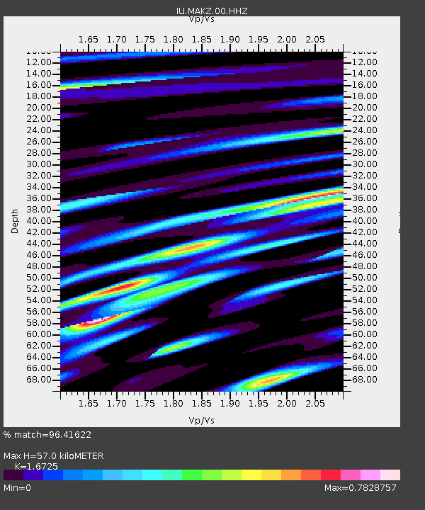
| Estimated Moho Depth: |
57.0 km |
| Estimated Crust Vp/Vs: |
1.67 |
| Assumed Crust Vp: |
6.571 km/s |
| Estimated Crust Vs: |
3.929 km/s |
| Estimated Crust Poisson's Ratio: |
0.22 |
|
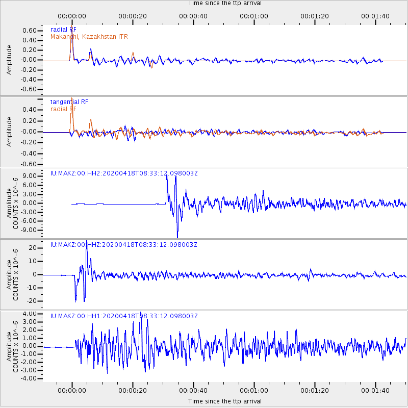
| Radial Match: |
96.41622 % |
| Radial Bump: |
400 |
| Transverse Match: |
90.425835 % |
| Transverse Bump: |
400 |
| SOD ConfigId: |
21166931 |
| Insert Time: |
2020-05-02 08:41:53.141 +0000 |
| GWidth: |
2.5 |
| Max Bumps: |
400 |
| Tol: |
0.001 |
|
Signal To Noise
| Channel | StoN | STA | LTA |
| IU:MAKZ:00:HHZ:20200418T08:33:12.098003Z | 178.70319 | 9.421886E-6 | 5.272366E-8 |
| IU:MAKZ:00:HH1:20200418T08:33:12.098003Z | 26.153772 | 6.751394E-7 | 2.5814227E-8 |
| IU:MAKZ:00:HH2:20200418T08:33:12.098003Z | 147.60109 | 4.35862E-6 | 2.9529726E-8 |
| Arrivals |
| Ps | 6.2 SECOND |
| PpPs | 22 SECOND |
| PsPs/PpSs | 28 SECOND |


