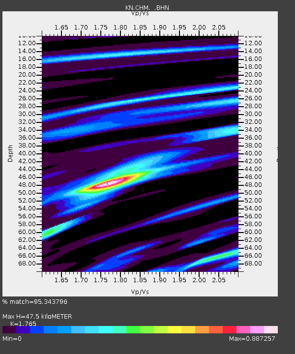
CHM KN.CHM - Earthquake Result Viewer
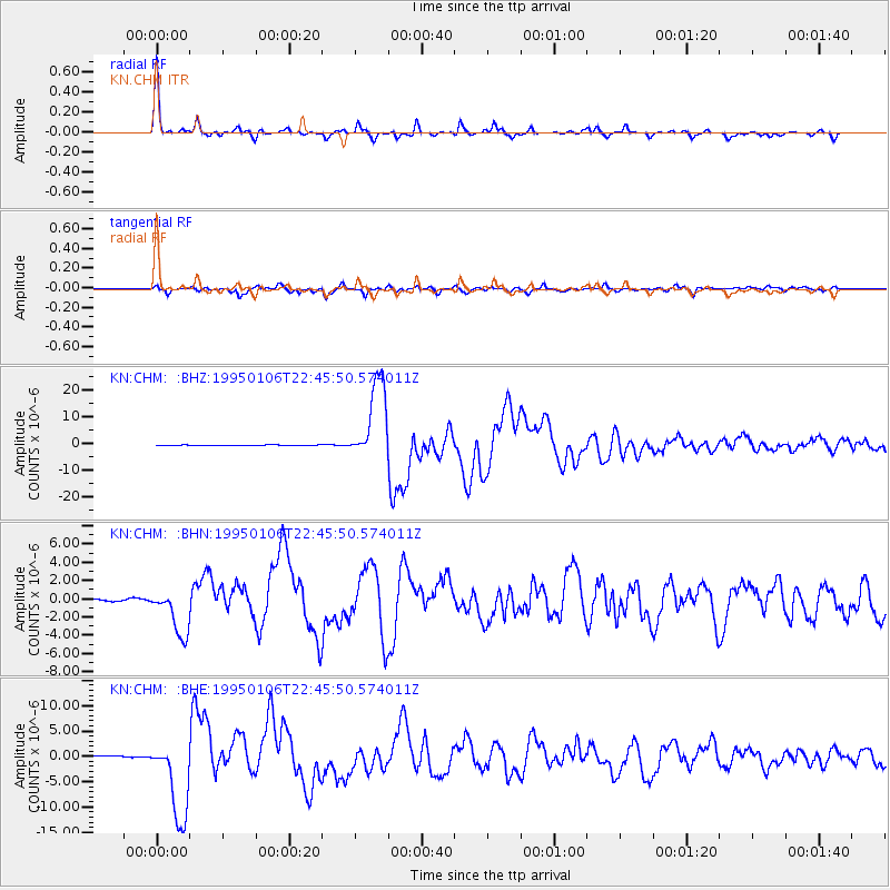
Earthquake location: Near East Coast Of Honshu, Japan
Earthquake latitude/longitude: 40.2/142.2
Earthquake time(UTC): 1995/01/06 (006) 22:37:37 GMT
Earthquake Depth: 57 km
Earthquake Magnitude: 6.7 MB, 6.6 UNKNOWN, 7.0 MW
Earthquake Catalog/Contributor: WHDF/NEIC
Network: KN Kyrgyz Seismic Telemetry Network
Station: CHM KN.CHM
Lat/Lon: 43.00 N/74.75 E
Elevation: 655 m
Distance: 49.3 deg
Az: 296.613 deg
Baz: 68.911 deg
Ray Param: 0.06863864
Estimated Moho Depth: 47.5 km
Estimated Crust Vp/Vs: 1.76
Assumed Crust Vp: 6.306 km/s
Estimated Crust Vs: 3.573 km/s
Estimated Crust Poisson's Ratio: 0.26
Radial Match: 95.343796 %
Radial Bump: 259
Transverse Match: 84.515 %
Transverse Bump: 400
SOD ConfigId: 6273
Insert Time: 2010-03-08 19:26:05.742 +0000
GWidth: 2.5
Max Bumps: 400
Tol: 0.001

Signal To Noise

ChannelStoNSTALTA
KN:CHM: :BHN:19950106T22:45:50.574011Z6.91263872.3210362E-63.3576703E-7
KN:CHM: :BHE:19950106T22:45:50.574011Z29.8062738.054154E-62.7021673E-7
KN:CHM: :BHZ:19950106T22:45:50.574011Z114.5225141.5237289E-51.330506E-7
Arrivals
Ps6.1 SECOND
PpPs20 SECOND
PsPs/PpSs26 SECOND