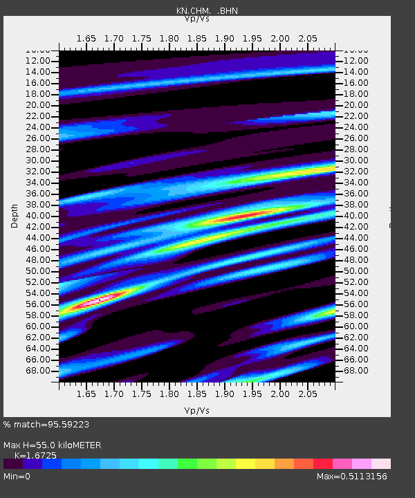
CHM KN.CHM - Earthquake Result Viewer
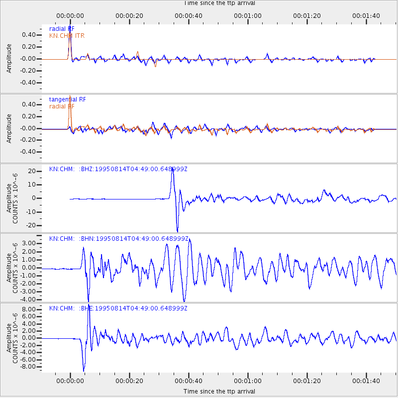
Earthquake location: New Britain Region, P.N.G.
Earthquake latitude/longitude: -4.8/151.5
Earthquake time(UTC): 1995/08/14 (226) 04:37:17 GMT
Earthquake Depth: 126 km
Earthquake Magnitude: 6.3 MB, 6.3 MS, 6.4 UNKNOWN
Earthquake Catalog/Contributor: WHDF/NEIC
Network: KN Kyrgyz Seismic Telemetry Network
Station: CHM KN.CHM
Lat/Lon: 43.00 N/74.75 E
Elevation: 655 m
Distance: 83.6 deg
Az: 314.065 deg
Baz: 102.58 deg
Ray Param: 0.04575684
Estimated Moho Depth: 55.0 km
Estimated Crust Vp/Vs: 1.67
Assumed Crust Vp: 6.306 km/s
Estimated Crust Vs: 3.77 km/s
Estimated Crust Poisson's Ratio: 0.22
Radial Match: 95.59223 %
Radial Bump: 257
Transverse Match: 92.12341 %
Transverse Bump: 400
SOD ConfigId: 6273
Insert Time: 2010-03-08 19:26:36.722 +0000
GWidth: 2.5
Max Bumps: 400
Tol: 0.001

Signal To Noise

ChannelStoNSTALTA
KN:CHM: :BHN:19950814T04:49:00.648999Z31.635128.415957E-72.6603209E-8
KN:CHM: :BHE:19950814T04:49:00.648999Z106.615542.9283094E-62.7466065E-8
KN:CHM: :BHZ:19950814T04:49:00.648999Z145.88367.7070035E-65.2829815E-8
Arrivals
Ps6.0 SECOND
PpPs23 SECOND
PsPs/PpSs29 SECOND