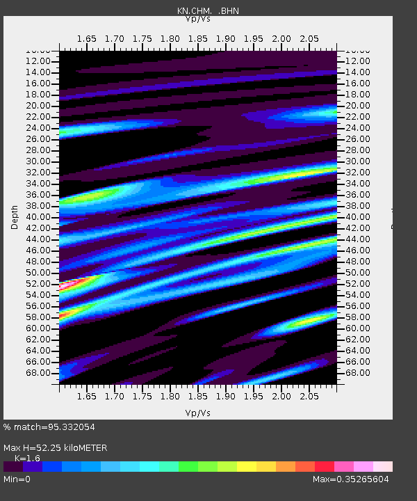
CHM KN.CHM - Earthquake Result Viewer

Earthquake location: New Ireland Region, P.N.G.
Earthquake latitude/longitude: -5.2/153.4
Earthquake time(UTC): 1995/08/17 (229) 10:01:27 GMT
Earthquake Depth: 33 km
Earthquake Magnitude: 5.5 MB, 6.4 MS, 6.5 UNKNOWN, 6.4 MW
Earthquake Catalog/Contributor: WHDF/NEIC
Network: KN Kyrgyz Seismic Telemetry Network
Station: CHM KN.CHM
Lat/Lon: 43.00 N/74.75 E
Elevation: 655 m
Distance: 85.2 deg
Az: 313.797 deg
Baz: 101.513 deg
Ray Param: 0.044858668
Estimated Moho Depth: 52.25 km
Estimated Crust Vp/Vs: 1.60
Assumed Crust Vp: 6.306 km/s
Estimated Crust Vs: 3.941 km/s
Estimated Crust Poisson's Ratio: 0.18
Radial Match: 95.332054 %
Radial Bump: 261
Transverse Match: 88.67817 %
Transverse Bump: 400
SOD ConfigId: 6273
Insert Time: 2010-03-08 19:26:39.564 +0000
GWidth: 2.5
Max Bumps: 400
Tol: 0.001

Signal To Noise

ChannelStoNSTALTA
KN:CHM: :BHN:19950817T10:13:29.698999Z0.85367043.376243E-83.954972E-8
KN:CHM: :BHE:19950817T10:13:29.698999Z3.5706551.1727113E-73.284303E-8
KN:CHM: :BHZ:19950817T10:13:29.698999Z4.2329882.388485E-75.6425506E-8
Arrivals
Ps5.1 SECOND
PpPs21 SECOND
PsPs/PpSs26 SECOND