You are here: Home > Network List > TA - USArray Transportable Network (new EarthScope stations) Stations List
> Station J16K Anvik River, AK, USA > Earthquake Result Viewer
J16K Anvik River, AK, USA - Earthquake Result Viewer
| Earthquake location: |
Bonin Islands, Japan Region |
| Earthquake latitude/longitude: |
27.1/140.1 |
| Earthquake time(UTC): |
2020/04/18 (109) 08:25:37 GMT |
| Earthquake Depth: |
454 km |
| Earthquake Magnitude: |
6.6 Mww |
| Earthquake Catalog/Contributor: |
NEIC PDE/us |
|
| Network: |
TA USArray Transportable Network (new EarthScope stations) |
| Station: |
J16K Anvik River, AK, USA |
| Lat/Lon: |
63.28 N/160.60 W |
| Elevation: |
328 m |
|
| Distance: |
52.4 deg |
| Az: |
29.381 deg |
| Baz: |
255.31 deg |
| Ray Param: |
0.06491252 |
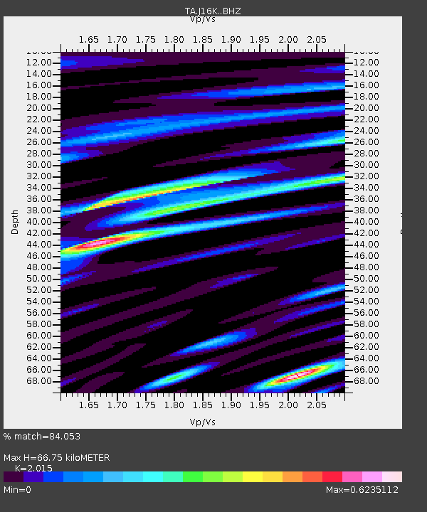
| Estimated Moho Depth: |
66.75 km |
| Estimated Crust Vp/Vs: |
2.02 |
| Assumed Crust Vp: |
6.276 km/s |
| Estimated Crust Vs: |
3.115 km/s |
| Estimated Crust Poisson's Ratio: |
0.34 |
|
| Radial Match: |
84.053 % |
| Radial Bump: |
400 |
| Transverse Match: |
66.80711 % |
| Transverse Bump: |
400 |
| SOD ConfigId: |
21166931 |
| Insert Time: |
2020-05-02 08:49:33.465 +0000 |
| GWidth: |
2.5 |
| Max Bumps: |
400 |
| Tol: |
0.001 |
|

Signal To Noise
| Channel | StoN | STA | LTA |
| TA:J16K: :BHZ:20200418T08:33:35.074993Z | 13.085085 | 2.0070554E-6 | 1.5338497E-7 |
| TA:J16K: :BHN:20200418T08:33:35.074993Z | 2.3311737 | 4.7038546E-7 | 2.0178054E-7 |
| TA:J16K: :BHE:20200418T08:33:35.074993Z | 9.057957 | 9.759922E-7 | 1.07749706E-7 |
| Arrivals |
| Ps | 11 SECOND |
| PpPs | 31 SECOND |
| PsPs/PpSs | 42 SECOND |


