You are here: Home > Network List > TA - USArray Transportable Network (new EarthScope stations) Stations List
> Station J29N Klondike Camp, Yukon, CA > Earthquake Result Viewer
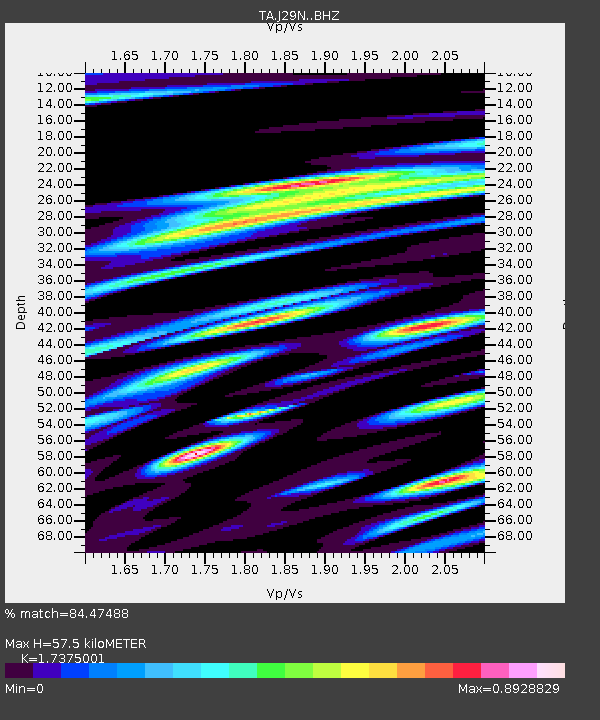
J29N Klondike Camp, Yukon, CA - Earthquake Result Viewer
| Earthquake location: |
Bonin Islands, Japan Region |
| Earthquake latitude/longitude: |
27.1/140.1 |
| Earthquake time(UTC): |
2020/04/18 (109) 08:25:37 GMT |
| Earthquake Depth: |
454 km |
| Earthquake Magnitude: |
6.6 Mww |
| Earthquake Catalog/Contributor: |
NEIC PDE/us |
|
| Network: |
TA USArray Transportable Network (new EarthScope stations) |
| Station: |
J29N Klondike Camp, Yukon, CA |
| Lat/Lon: |
64.45 N/138.22 W |
| Elevation: |
982 m |
|
| Distance: |
62.3 deg |
| Az: |
28.985 deg |
| Baz: |
275.218 deg |
| Ray Param: |
0.05869534 |
| Estimated Moho Depth: |
57.5 km |
| Estimated Crust Vp/Vs: |
1.74 |
| Assumed Crust Vp: |
6.566 km/s |
| Estimated Crust Vs: |
3.779 km/s |
| Estimated Crust Poisson's Ratio: |
0.25 |
|
| Radial Match: |
84.47488 % |
| Radial Bump: |
400 |
| Transverse Match: |
82.16355 % |
| Transverse Bump: |
400 |
| SOD ConfigId: |
21166931 |
| Insert Time: |
2020-05-02 08:49:34.454 +0000 |
| GWidth: |
2.5 |
| Max Bumps: |
400 |
| Tol: |
0.001 |
|

Signal To Noise
| Channel | StoN | STA | LTA |
| TA:J29N: :BHZ:20200418T08:34:43.075023Z | 21.077625 | 3.2898229E-6 | 1.5608128E-7 |
| TA:J29N: :BHN:20200418T08:34:43.075023Z | 10.260457 | 1.5668991E-6 | 1.527124E-7 |
| TA:J29N: :BHE:20200418T08:34:43.075023Z | 40.836937 | 3.108257E-6 | 7.611387E-8 |
| Arrivals |
| Ps | 6.8 SECOND |
| PpPs | 23 SECOND |
| PsPs/PpSs | 30 SECOND |


