You are here: Home > Network List > TA - USArray Transportable Network (new EarthScope stations) Stations List
> Station K15K Wolf Creek Mountain, AK, USA > Earthquake Result Viewer
K15K Wolf Creek Mountain, AK, USA - Earthquake Result Viewer
| Earthquake location: |
Bonin Islands, Japan Region |
| Earthquake latitude/longitude: |
27.1/140.1 |
| Earthquake time(UTC): |
2020/04/18 (109) 08:25:37 GMT |
| Earthquake Depth: |
454 km |
| Earthquake Magnitude: |
6.6 Mww |
| Earthquake Catalog/Contributor: |
NEIC PDE/us |
|
| Network: |
TA USArray Transportable Network (new EarthScope stations) |
| Station: |
K15K Wolf Creek Mountain, AK, USA |
| Lat/Lon: |
62.29 N/161.53 W |
| Elevation: |
346 m |
|
| Distance: |
51.7 deg |
| Az: |
30.462 deg |
| Baz: |
255.15 deg |
| Ray Param: |
0.0653375 |
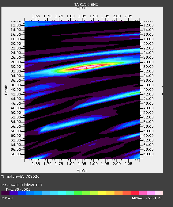
| Estimated Moho Depth: |
30.0 km |
| Estimated Crust Vp/Vs: |
1.87 |
| Assumed Crust Vp: |
6.276 km/s |
| Estimated Crust Vs: |
3.361 km/s |
| Estimated Crust Poisson's Ratio: |
0.30 |
|
| Radial Match: |
85.703026 % |
| Radial Bump: |
400 |
| Transverse Match: |
66.88091 % |
| Transverse Bump: |
400 |
| SOD ConfigId: |
21166931 |
| Insert Time: |
2020-05-02 08:49:39.182 +0000 |
| GWidth: |
2.5 |
| Max Bumps: |
400 |
| Tol: |
0.001 |
|
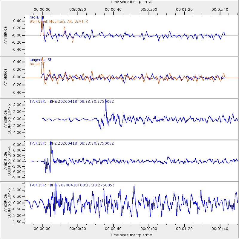
Signal To Noise
| Channel | StoN | STA | LTA |
| TA:K15K: :BHZ:20200418T08:33:30.275005Z | 18.532032 | 2.9111775E-6 | 1.5708896E-7 |
| TA:K15K: :BHN:20200418T08:33:30.275005Z | 1.9802706 | 3.7109362E-7 | 1.8739541E-7 |
| TA:K15K: :BHE:20200418T08:33:30.275005Z | 4.4800596 | 1.0726395E-6 | 2.3942528E-7 |
| Arrivals |
| Ps | 4.3 SECOND |
| PpPs | 13 SECOND |
| PsPs/PpSs | 17 SECOND |


