You are here: Home > Network List > KN - Kyrgyz Seismic Telemetry Network Stations List
> Station CHM KN.CHM > Earthquake Result Viewer
CHM KN.CHM - Earthquake Result Viewer
| Earthquake location: |
Mariana Islands |
| Earthquake latitude/longitude: |
18.9/145.0 |
| Earthquake time(UTC): |
1995/08/24 (236) 07:54:41 GMT |
| Earthquake Depth: |
598 km |
| Earthquake Magnitude: |
5.3 MB, 6.1 UNKNOWN |
| Earthquake Catalog/Contributor: |
WHDF/NEIC |
|
| Network: |
KN Kyrgyz Seismic Telemetry Network |
| Station: |
CHM KN.CHM |
| Lat/Lon: |
43.00 N/74.75 E |
| Elevation: |
655 m |
|
| Distance: |
63.0 deg |
| Az: |
309.235 deg |
| Baz: |
88.84 deg |
| Ray Param: |
0.057534788 |
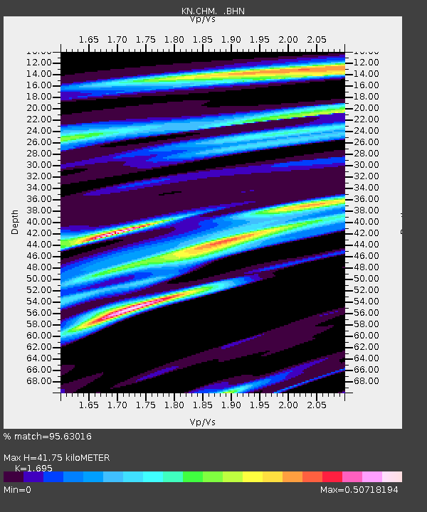
| Estimated Moho Depth: |
41.75 km |
| Estimated Crust Vp/Vs: |
1.70 |
| Assumed Crust Vp: |
6.306 km/s |
| Estimated Crust Vs: |
3.72 km/s |
| Estimated Crust Poisson's Ratio: |
0.23 |
|
| Radial Match: |
95.63016 % |
| Radial Bump: |
400 |
| Transverse Match: |
92.018974 % |
| Transverse Bump: |
400 |
| SOD ConfigId: |
6273 |
| Insert Time: |
2010-03-08 19:26:42.385 +0000 |
| GWidth: |
2.5 |
| Max Bumps: |
400 |
| Tol: |
0.001 |
|
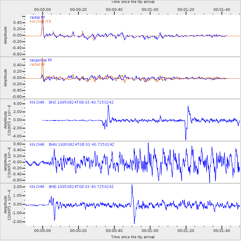
Signal To Noise
| Channel | StoN | STA | LTA |
| KN:CHM: :BHN:19950824T08:03:40.725024Z | 0.6987933 | 3.2248817E-8 | 4.6149292E-8 |
| KN:CHM: :BHE:19950824T08:03:40.725024Z | 8.735234 | 2.7599955E-7 | 3.1596127E-8 |
| KN:CHM: :BHZ:19950824T08:03:40.725024Z | 12.739133 | 5.95003E-7 | 4.6706706E-8 |
| Arrivals |
| Ps | 4.8 SECOND |
| PpPs | 17 SECOND |
| PsPs/PpSs | 22 SECOND |


