You are here: Home > Network List > TA - USArray Transportable Network (new EarthScope stations) Stations List
> Station P33M Teslin, Yukon, CA > Earthquake Result Viewer
P33M Teslin, Yukon, CA - Earthquake Result Viewer
| Earthquake location: |
Bonin Islands, Japan Region |
| Earthquake latitude/longitude: |
27.1/140.1 |
| Earthquake time(UTC): |
2020/04/18 (109) 08:25:37 GMT |
| Earthquake Depth: |
454 km |
| Earthquake Magnitude: |
6.6 Mww |
| Earthquake Catalog/Contributor: |
NEIC PDE/us |
|
| Network: |
TA USArray Transportable Network (new EarthScope stations) |
| Station: |
P33M Teslin, Yukon, CA |
| Lat/Lon: |
60.21 N/132.82 W |
| Elevation: |
1066 m |
|
| Distance: |
65.4 deg |
| Az: |
33.252 deg |
| Baz: |
281.877 deg |
| Ray Param: |
0.05672529 |
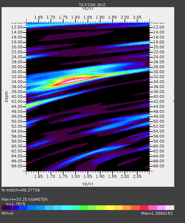
| Estimated Moho Depth: |
33.25 km |
| Estimated Crust Vp/Vs: |
1.80 |
| Assumed Crust Vp: |
6.419 km/s |
| Estimated Crust Vs: |
3.571 km/s |
| Estimated Crust Poisson's Ratio: |
0.28 |
|
| Radial Match: |
86.37736 % |
| Radial Bump: |
400 |
| Transverse Match: |
77.34137 % |
| Transverse Bump: |
400 |
| SOD ConfigId: |
21166931 |
| Insert Time: |
2020-05-02 08:50:33.254 +0000 |
| GWidth: |
2.5 |
| Max Bumps: |
400 |
| Tol: |
0.001 |
|

Signal To Noise
| Channel | StoN | STA | LTA |
| TA:P33M: :BHZ:20200418T08:35:03.049999Z | 19.874949 | 2.150633E-6 | 1.08208226E-7 |
| TA:P33M: :BHN:20200418T08:35:03.049999Z | 1.9648845 | 2.5893112E-7 | 1.317793E-7 |
| TA:P33M: :BHE:20200418T08:35:03.049999Z | 9.309153 | 9.036677E-7 | 9.7073034E-8 |
| Arrivals |
| Ps | 4.3 SECOND |
| PpPs | 14 SECOND |
| PsPs/PpSs | 18 SECOND |


