You are here: Home > Network List > TA - USArray Transportable Network (new EarthScope stations) Stations List
> Station Q20K Shuyak Island, AK, USA > Earthquake Result Viewer
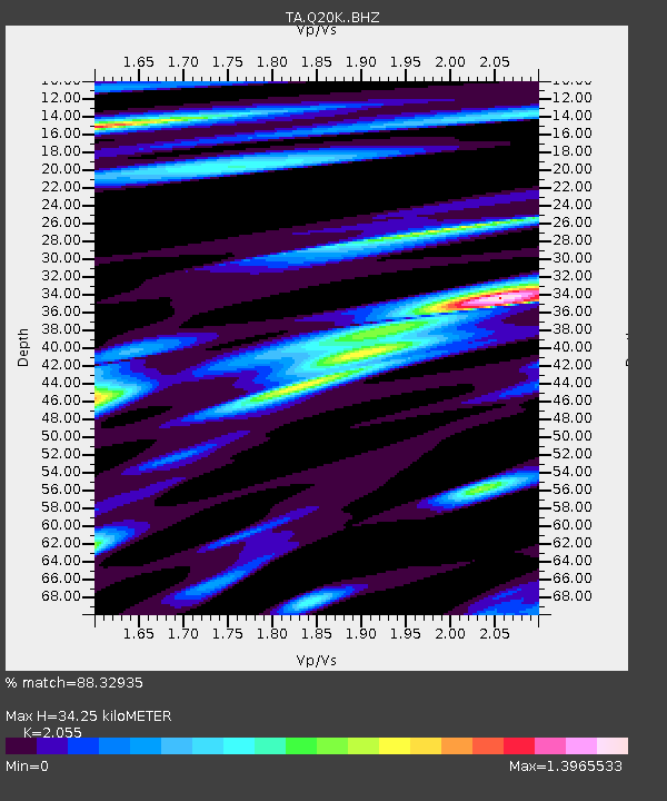
Q20K Shuyak Island, AK, USA - Earthquake Result Viewer
| Earthquake location: |
Bonin Islands, Japan Region |
| Earthquake latitude/longitude: |
27.1/140.1 |
| Earthquake time(UTC): |
2020/04/18 (109) 08:25:37 GMT |
| Earthquake Depth: |
454 km |
| Earthquake Magnitude: |
6.6 Mww |
| Earthquake Catalog/Contributor: |
NEIC PDE/us |
|
| Network: |
TA USArray Transportable Network (new EarthScope stations) |
| Station: |
Q20K Shuyak Island, AK, USA |
| Lat/Lon: |
58.61 N/152.39 W |
| Elevation: |
180 m |
|
| Distance: |
55.6 deg |
| Az: |
35.884 deg |
| Baz: |
266.311 deg |
| Ray Param: |
0.06290644 |
| Estimated Moho Depth: |
34.25 km |
| Estimated Crust Vp/Vs: |
2.06 |
| Assumed Crust Vp: |
5.989 km/s |
| Estimated Crust Vs: |
2.914 km/s |
| Estimated Crust Poisson's Ratio: |
0.34 |
|
| Radial Match: |
88.32935 % |
| Radial Bump: |
347 |
| Transverse Match: |
84.56572 % |
| Transverse Bump: |
400 |
| SOD ConfigId: |
21166931 |
| Insert Time: |
2020-05-02 08:50:38.486 +0000 |
| GWidth: |
2.5 |
| Max Bumps: |
400 |
| Tol: |
0.001 |
|

Signal To Noise
| Channel | StoN | STA | LTA |
| TA:Q20K: :BHZ:20200418T08:33:57.824993Z | 29.368084 | 4.518518E-6 | 1.5385812E-7 |
| TA:Q20K: :BHN:20200418T08:33:57.824993Z | 6.1107745 | 9.540446E-7 | 1.56125E-7 |
| TA:Q20K: :BHE:20200418T08:33:57.824993Z | 12.498133 | 2.7655867E-6 | 2.2128E-7 |
| Arrivals |
| Ps | 6.3 SECOND |
| PpPs | 17 SECOND |
| PsPs/PpSs | 23 SECOND |


