You are here: Home > Network List > TA - USArray Transportable Network (new EarthScope stations) Stations List
> Station R31K City Hall, Gustavus, AK, USA > Earthquake Result Viewer
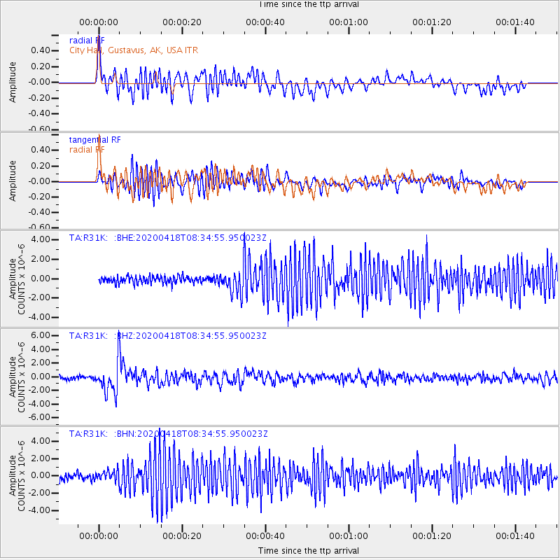
R31K City Hall, Gustavus, AK, USA - Earthquake Result Viewer
*The percent match for this event was below the threshold and hence no stack was calculated.
| Earthquake location: |
Bonin Islands, Japan Region |
| Earthquake latitude/longitude: |
27.1/140.1 |
| Earthquake time(UTC): |
2020/04/18 (109) 08:25:37 GMT |
| Earthquake Depth: |
454 km |
| Earthquake Magnitude: |
6.6 Mww |
| Earthquake Catalog/Contributor: |
NEIC PDE/us |
|
| Network: |
TA USArray Transportable Network (new EarthScope stations) |
| Station: |
R31K City Hall, Gustavus, AK, USA |
| Lat/Lon: |
58.41 N/135.74 W |
| Elevation: |
15 m |
|
| Distance: |
64.3 deg |
| Az: |
35.525 deg |
| Baz: |
280.334 deg |
| Ray Param: |
$rayparam |
*The percent match for this event was below the threshold and hence was not used in the summary stack. |
|
| Radial Match: |
71.504074 % |
| Radial Bump: |
400 |
| Transverse Match: |
68.696495 % |
| Transverse Bump: |
400 |
| SOD ConfigId: |
21166931 |
| Insert Time: |
2020-05-02 08:50:43.257 +0000 |
| GWidth: |
2.5 |
| Max Bumps: |
400 |
| Tol: |
0.001 |
|
Signal To Noise
| Channel | StoN | STA | LTA |
| TA:R31K: :BHZ:20200418T08:34:55.950023Z | 8.522002 | 2.3434525E-6 | 2.7498845E-7 |
| TA:R31K: :BHN:20200418T08:34:55.950023Z | 1.4567076 | 5.8939577E-7 | 4.0460816E-7 |
| TA:R31K: :BHE:20200418T08:34:55.950023Z | 3.6002634 | 1.219792E-6 | 3.3880633E-7 |
| Arrivals |
| Ps | |
| PpPs | |
| PsPs/PpSs | |


