You are here: Home > Network List > TJ - Tajikistan National Seismic Network Stations List
> Station CHGR Chuyangaron, Tajikistan > Earthquake Result Viewer
CHGR Chuyangaron, Tajikistan - Earthquake Result Viewer
| Earthquake location: |
Bonin Islands, Japan Region |
| Earthquake latitude/longitude: |
27.1/140.1 |
| Earthquake time(UTC): |
2020/04/18 (109) 08:25:37 GMT |
| Earthquake Depth: |
454 km |
| Earthquake Magnitude: |
6.6 Mww |
| Earthquake Catalog/Contributor: |
NEIC PDE/us |
|
| Network: |
TJ Tajikistan National Seismic Network |
| Station: |
CHGR Chuyangaron, Tajikistan |
| Lat/Lon: |
38.66 N/69.16 E |
| Elevation: |
1049 m |
|
| Distance: |
59.3 deg |
| Az: |
300.642 deg |
| Baz: |
78.31 deg |
| Ray Param: |
0.060558207 |
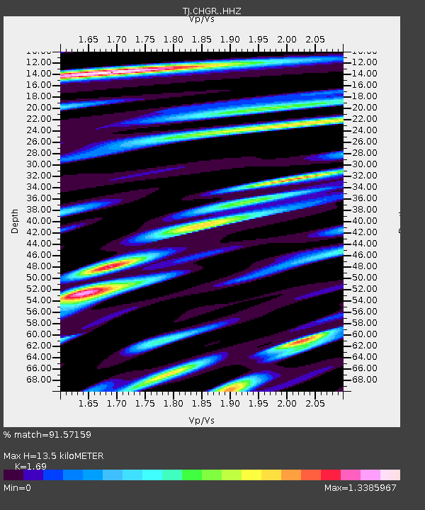
| Estimated Moho Depth: |
13.5 km |
| Estimated Crust Vp/Vs: |
1.69 |
| Assumed Crust Vp: |
6.483 km/s |
| Estimated Crust Vs: |
3.836 km/s |
| Estimated Crust Poisson's Ratio: |
0.23 |
|
| Radial Match: |
91.57159 % |
| Radial Bump: |
400 |
| Transverse Match: |
69.60578 % |
| Transverse Bump: |
400 |
| SOD ConfigId: |
21166931 |
| Insert Time: |
2020-05-02 08:51:06.755 +0000 |
| GWidth: |
2.5 |
| Max Bumps: |
400 |
| Tol: |
0.001 |
|

Signal To Noise
| Channel | StoN | STA | LTA |
| TJ:CHGR: :HHZ:20200418T08:34:23.450023Z | 150.21042 | 2.3395027E-5 | 1.5574837E-7 |
| TJ:CHGR: :HHN:20200418T08:34:23.450023Z | 56.00977 | 4.352451E-6 | 7.770878E-8 |
| TJ:CHGR: :HHE:20200418T08:34:23.450023Z | 187.25302 | 9.814798E-6 | 5.2414634E-8 |
| Arrivals |
| Ps | 1.5 SECOND |
| PpPs | 5.3 SECOND |
| PsPs/PpSs | 6.8 SECOND |


