You are here: Home > Network List > TJ - Tajikistan National Seismic Network Stations List
> Station CHRDR Chorukh Dayron, Tajikistan > Earthquake Result Viewer
CHRDR Chorukh Dayron, Tajikistan - Earthquake Result Viewer
| Earthquake location: |
Bonin Islands, Japan Region |
| Earthquake latitude/longitude: |
27.1/140.1 |
| Earthquake time(UTC): |
2020/04/18 (109) 08:25:37 GMT |
| Earthquake Depth: |
454 km |
| Earthquake Magnitude: |
6.6 Mww |
| Earthquake Catalog/Contributor: |
NEIC PDE/us |
|
| Network: |
TJ Tajikistan National Seismic Network |
| Station: |
CHRDR Chorukh Dayron, Tajikistan |
| Lat/Lon: |
40.39 N/69.67 E |
| Elevation: |
580 m |
|
| Distance: |
58.6 deg |
| Az: |
302.532 deg |
| Baz: |
79.609 deg |
| Ray Param: |
0.061003897 |
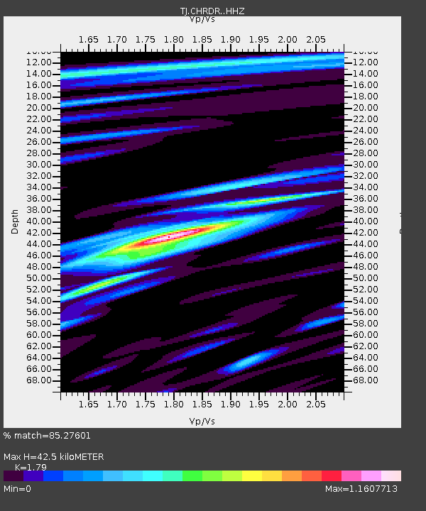
| Estimated Moho Depth: |
42.5 km |
| Estimated Crust Vp/Vs: |
1.79 |
| Assumed Crust Vp: |
6.316 km/s |
| Estimated Crust Vs: |
3.528 km/s |
| Estimated Crust Poisson's Ratio: |
0.27 |
|
| Radial Match: |
85.27601 % |
| Radial Bump: |
317 |
| Transverse Match: |
77.23893 % |
| Transverse Bump: |
363 |
| SOD ConfigId: |
21166931 |
| Insert Time: |
2020-05-02 08:51:07.667 +0000 |
| GWidth: |
2.5 |
| Max Bumps: |
400 |
| Tol: |
0.001 |
|

Signal To Noise
| Channel | StoN | STA | LTA |
| TJ:CHRDR: :HHZ:20200418T08:34:18.589977Z | 218.47034 | 2.3355375E-5 | 1.06904096E-7 |
| TJ:CHRDR: :HHN:20200418T08:34:18.589977Z | 31.907063 | 3.0823364E-6 | 9.660358E-8 |
| TJ:CHRDR: :HHE:20200418T08:34:18.589977Z | 110.22105 | 1.0953306E-5 | 9.937581E-8 |
| Arrivals |
| Ps | 5.6 SECOND |
| PpPs | 18 SECOND |
| PsPs/PpSs | 24 SECOND |


