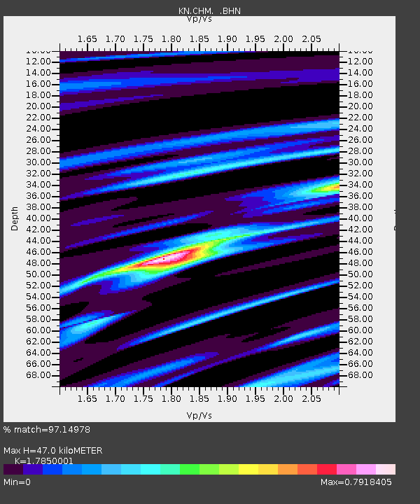
CHM KN.CHM - Earthquake Result Viewer
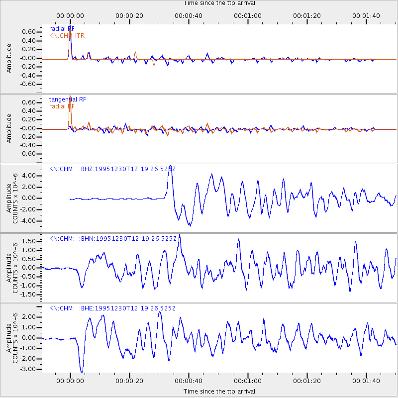
Earthquake location: Off East Coast Of Honshu, Japan
Earthquake latitude/longitude: 40.8/143.4
Earthquake time(UTC): 1995/12/30 (364) 12:11:07 GMT
Earthquake Depth: 33 km
Earthquake Magnitude: 5.7 MB, 6.2 MS, 6.4 UNKNOWN, 6.3 MW
Earthquake Catalog/Contributor: WHDF/NEIC
Network: KN Kyrgyz Seismic Telemetry Network
Station: CHM KN.CHM
Lat/Lon: 43.00 N/74.75 E
Elevation: 655 m
Distance: 49.8 deg
Az: 296.59 deg
Baz: 67.738 deg
Ray Param: 0.06839542
Estimated Moho Depth: 47.0 km
Estimated Crust Vp/Vs: 1.79
Assumed Crust Vp: 6.306 km/s
Estimated Crust Vs: 3.533 km/s
Estimated Crust Poisson's Ratio: 0.27
Radial Match: 97.14978 %
Radial Bump: 265
Transverse Match: 92.90846 %
Transverse Bump: 382
SOD ConfigId: 6273
Insert Time: 2010-03-08 19:27:01.090 +0000
GWidth: 2.5
Max Bumps: 400
Tol: 0.001

Signal To Noise

ChannelStoNSTALTA
KN:CHM: :BHN:19951230T12:19:26.525Z10.7078335.061152E-74.7265885E-8
KN:CHM: :BHE:19951230T12:19:26.525Z25.6724051.5225005E-65.9304945E-8
KN:CHM: :BHZ:19951230T12:19:26.525Z37.1840252.7650647E-67.436162E-8
Arrivals
Ps6.2 SECOND
PpPs20 SECOND
PsPs/PpSs26 SECOND