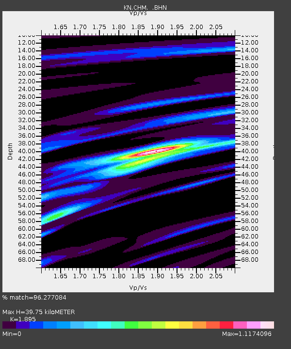
CHM KN.CHM - Earthquake Result Viewer
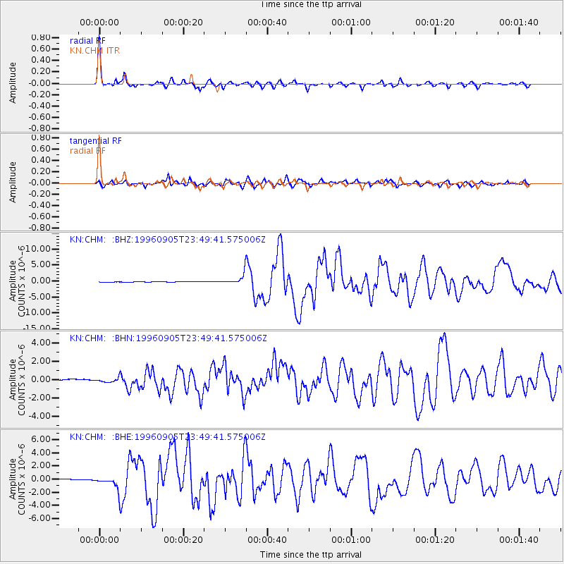
Earthquake location: Taiwan Region
Earthquake latitude/longitude: 21.9/121.5
Earthquake time(UTC): 1996/09/05 (249) 23:42:06 GMT
Earthquake Depth: 20 km
Earthquake Magnitude: 6.4 MB, 6.6 MS, 6.8 UNKNOWN, 6.8 ME
Earthquake Catalog/Contributor: WHDF/NEIC
Network: KN Kyrgyz Seismic Telemetry Network
Station: CHM KN.CHM
Lat/Lon: 43.00 N/74.75 E
Elevation: 655 m
Distance: 44.0 deg
Az: 309.767 deg
Baz: 103.34 deg
Ray Param: 0.072135575
Estimated Moho Depth: 39.75 km
Estimated Crust Vp/Vs: 1.89
Assumed Crust Vp: 6.306 km/s
Estimated Crust Vs: 3.328 km/s
Estimated Crust Poisson's Ratio: 0.31
Radial Match: 96.277084 %
Radial Bump: 328
Transverse Match: 85.86814 %
Transverse Bump: 400
SOD ConfigId: 6273
Insert Time: 2010-03-08 19:27:12.609 +0000
GWidth: 2.5
Max Bumps: 400
Tol: 0.001

Signal To Noise

ChannelStoNSTALTA
KN:CHM: :BHN:19960905T23:49:41.575006Z1.23567652.660174E-72.1528078E-7
KN:CHM: :BHE:19960905T23:49:41.575006Z10.053981.0106378E-61.0052117E-7
KN:CHM: :BHZ:19960905T23:49:41.575006Z30.9437311.730015E-65.590842E-8
Arrivals
Ps6.0 SECOND
PpPs17 SECOND
PsPs/PpSs23 SECOND