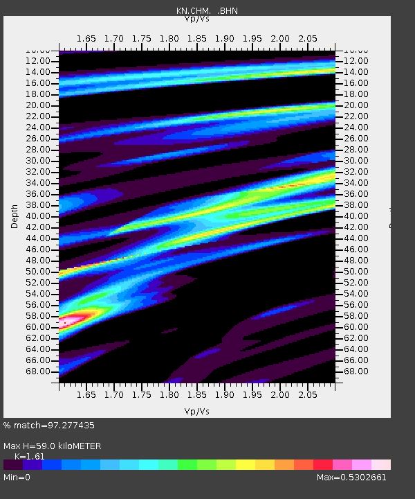
CHM KN.CHM - Earthquake Result Viewer
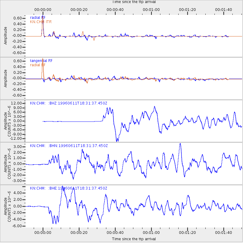
Earthquake location: Samar, Philippines
Earthquake latitude/longitude: 12.6/125.2
Earthquake time(UTC): 1996/06/11 (163) 18:22:55 GMT
Earthquake Depth: 33 km
Earthquake Magnitude: 6.0 MB, 7.0 MS, 7.2 UNKNOWN, 7.1 MW
Earthquake Catalog/Contributor: WHDF/NEIC
Network: KN Kyrgyz Seismic Telemetry Network
Station: CHM KN.CHM
Lat/Lon: 43.00 N/74.75 E
Elevation: 655 m
Distance: 52.8 deg
Az: 314.825 deg
Baz: 109.313 deg
Ray Param: 0.066432275
Estimated Moho Depth: 59.0 km
Estimated Crust Vp/Vs: 1.61
Assumed Crust Vp: 6.306 km/s
Estimated Crust Vs: 3.917 km/s
Estimated Crust Poisson's Ratio: 0.19
Radial Match: 97.277435 %
Radial Bump: 301
Transverse Match: 83.00859 %
Transverse Bump: 400
SOD ConfigId: 6273
Insert Time: 2010-03-08 19:27:34.354 +0000
GWidth: 2.5
Max Bumps: 400
Tol: 0.001

Signal To Noise

ChannelStoNSTALTA
KN:CHM: :BHN:19960611T18:31:37.450Z0.99631332.7681514E-72.7783946E-7
KN:CHM: :BHE:19960611T18:31:37.450Z19.5618889.81449E-75.017149E-8
KN:CHM: :BHZ:19960611T18:31:37.450Z32.3067781.8116992E-65.607799E-8
Arrivals
Ps6.0 SECOND
PpPs23 SECOND
PsPs/PpSs29 SECOND