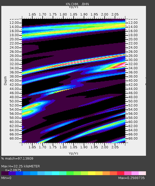
CHM KN.CHM - Earthquake Result Viewer
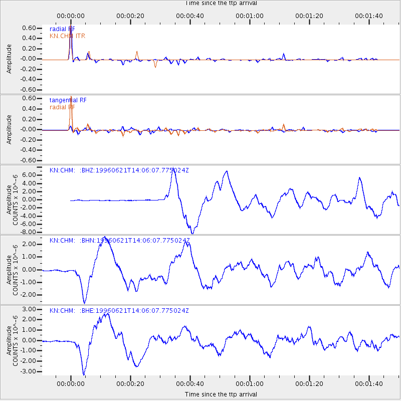
Earthquake location: Off East Coast Of Kamchatka
Earthquake latitude/longitude: 51.6/159.1
Earthquake time(UTC): 1996/06/21 (173) 13:57:10 GMT
Earthquake Depth: 20 km
Earthquake Magnitude: 6.0 MB, 6.6 MS, 7.0 UNKNOWN, 6.5 MS
Earthquake Catalog/Contributor: WHDF/NEIC
Network: KN Kyrgyz Seismic Telemetry Network
Station: CHM KN.CHM
Lat/Lon: 43.00 N/74.75 E
Elevation: 655 m
Distance: 54.8 deg
Az: 296.741 deg
Baz: 49.442 deg
Ray Param: 0.06516627
Estimated Moho Depth: 32.25 km
Estimated Crust Vp/Vs: 2.10
Assumed Crust Vp: 6.306 km/s
Estimated Crust Vs: 3.006 km/s
Estimated Crust Poisson's Ratio: 0.35
Radial Match: 97.13909 %
Radial Bump: 322
Transverse Match: 91.31659 %
Transverse Bump: 400
SOD ConfigId: 6273
Insert Time: 2010-03-08 19:27:37.969 +0000
GWidth: 2.5
Max Bumps: 400
Tol: 0.001

Signal To Noise

ChannelStoNSTALTA
KN:CHM: :BHN:19960621T14:06:07.775024Z25.741291.0526225E-64.0892374E-8
KN:CHM: :BHE:19960621T14:06:07.775024Z40.355871.4077795E-63.488413E-8
KN:CHM: :BHZ:19960621T14:06:07.775024Z79.850933.4382272E-64.3058073E-8
Arrivals
Ps5.9 SECOND
PpPs15 SECOND
PsPs/PpSs21 SECOND