You are here: Home > Network List > UW - Pacific Northwest Regional Seismic Network Stations List
> Station FISH Seaside, OR, USA > Earthquake Result Viewer
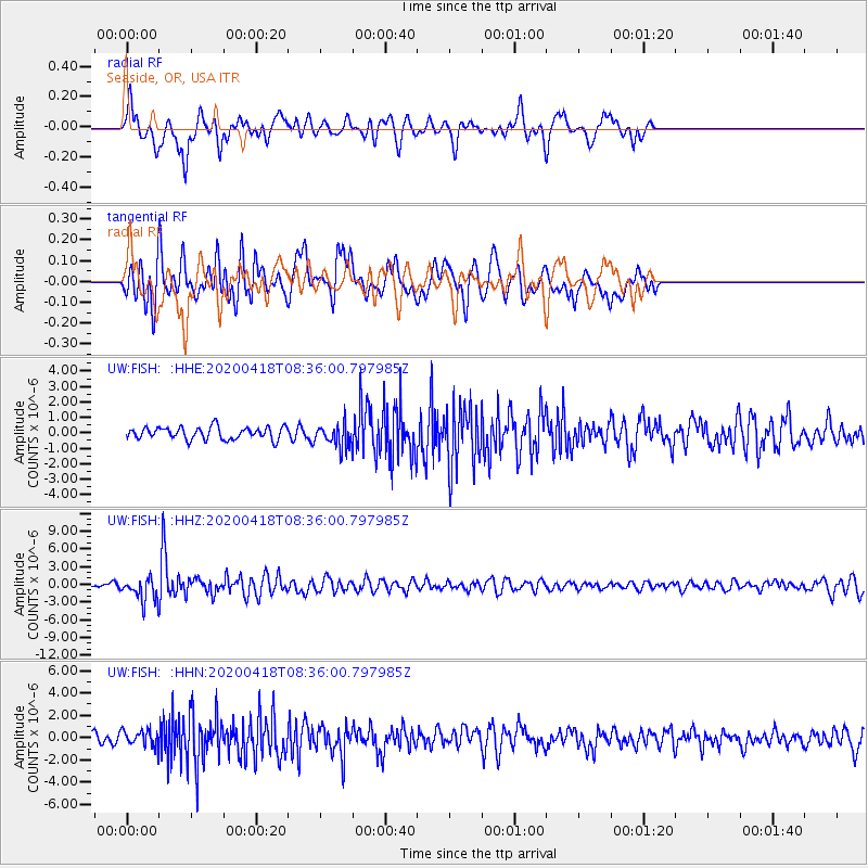
FISH Seaside, OR, USA - Earthquake Result Viewer
*The percent match for this event was below the threshold and hence no stack was calculated.
| Earthquake location: |
Bonin Islands, Japan Region |
| Earthquake latitude/longitude: |
27.1/140.1 |
| Earthquake time(UTC): |
2020/04/18 (109) 08:25:37 GMT |
| Earthquake Depth: |
454 km |
| Earthquake Magnitude: |
6.6 Mww |
| Earthquake Catalog/Contributor: |
NEIC PDE/us |
|
| Network: |
UW Pacific Northwest Regional Seismic Network |
| Station: |
FISH Seaside, OR, USA |
| Lat/Lon: |
45.93 N/123.56 W |
| Elevation: |
325 m |
|
| Distance: |
75.1 deg |
| Az: |
45.861 deg |
| Baz: |
293.608 deg |
| Ray Param: |
$rayparam |
*The percent match for this event was below the threshold and hence was not used in the summary stack. |
|
| Radial Match: |
61.607487 % |
| Radial Bump: |
400 |
| Transverse Match: |
69.74017 % |
| Transverse Bump: |
400 |
| SOD ConfigId: |
21166931 |
| Insert Time: |
2020-05-02 08:54:46.746 +0000 |
| GWidth: |
2.5 |
| Max Bumps: |
400 |
| Tol: |
0.001 |
|
Signal To Noise
| Channel | StoN | STA | LTA |
| UW:FISH: :HHZ:20200418T08:36:00.797985Z | 4.298661 | 1.9109539E-6 | 4.445463E-7 |
| UW:FISH: :HHN:20200418T08:36:00.797985Z | 1.4775178 | 6.864408E-7 | 4.6459053E-7 |
| UW:FISH: :HHE:20200418T08:36:00.797985Z | 1.877053 | 7.485718E-7 | 3.9880163E-7 |
| Arrivals |
| Ps | |
| PpPs | |
| PsPs/PpSs | |


