CHM KN.CHM - Earthquake Result Viewer
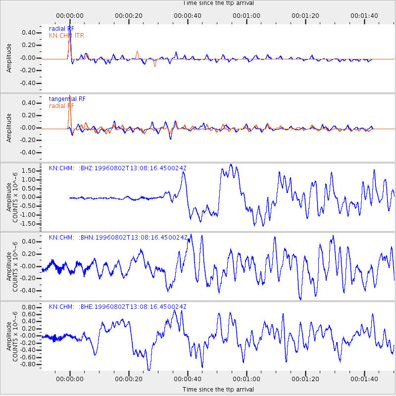
Earthquake location: Solomon Islands
Earthquake latitude/longitude: -10.8/161.4
Earthquake time(UTC): 1996/08/02 (215) 12:55:29 GMT
Earthquake Depth: 33 km
Earthquake Magnitude: 6.2 MB, 7.1 MS, 6.9 UNKNOWN, 6.9 MW
Earthquake Catalog/Contributor: WHDF/NEIC
Network: KN Kyrgyz Seismic Telemetry Network
Station: CHM KN.CHM
Lat/Lon: 43.00 N/74.75 E
Elevation: 655 m
Distance: 94.9 deg
Az: 312.687 deg
Baz: 100.098 deg
Ray Param: 0.04092361
Estimated Moho Depth: 31.0 km
Estimated Crust Vp/Vs: 2.07
Assumed Crust Vp: 6.306 km/s
Estimated Crust Vs: 3.046 km/s
Estimated Crust Poisson's Ratio: 0.35
Radial Match: 97.44301 %
Radial Bump: 285
Transverse Match: 87.94226 %
Transverse Bump: 400
SOD ConfigId: 6273
Insert Time: 2010-03-08 19:27:47.927 +0000
GWidth: 2.5
Max Bumps: 400
Tol: 0.001

Signal To Noise

ChannelStoNSTALTA
KN:CHM: :BHN:19960802T13:08:16.450024Z1.90168587.735446E-84.067678E-8
KN:CHM: :BHE:19960802T13:08:16.450024Z2.13010576.14576E-82.88519E-8
KN:CHM: :BHZ:19960802T13:08:16.450024Z4.4694731.9033851E-74.2586343E-8
Arrivals
Ps5.3 SECOND
PpPs15 SECOND
PsPs/PpSs20 SECOND