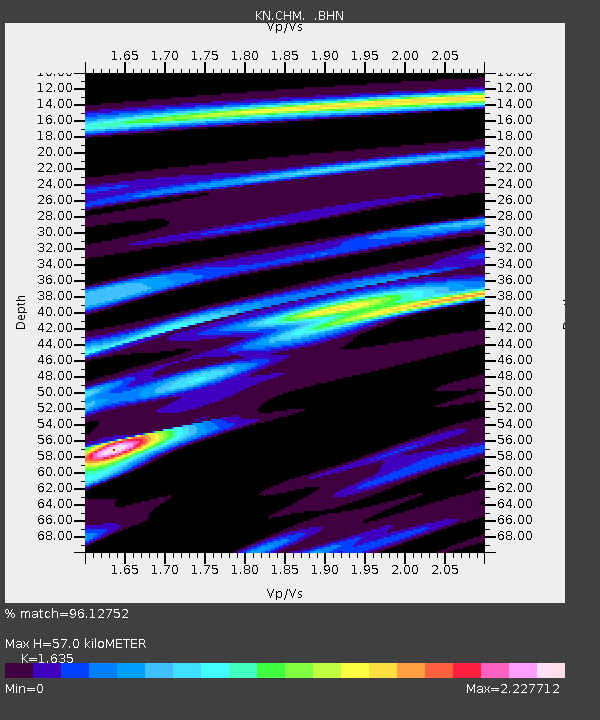
CHM KN.CHM - Earthquake Result Viewer
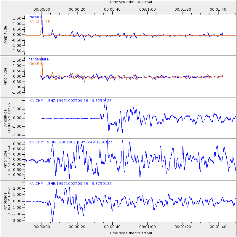
Earthquake location: Samar, Philippines
Earthquake latitude/longitude: 11.8/125.5
Earthquake time(UTC): 1996/10/02 (276) 09:48:01 GMT
Earthquake Depth: 33 km
Earthquake Magnitude: 6.0 MB, 6.4 MS, 6.4 UNKNOWN, 6.3 MW
Earthquake Catalog/Contributor: WHDF/NEIC
Network: KN Kyrgyz Seismic Telemetry Network
Station: CHM KN.CHM
Lat/Lon: 43.00 N/74.75 E
Elevation: 655 m
Distance: 53.7 deg
Az: 315.171 deg
Baz: 109.777 deg
Ray Param: 0.065877944
Estimated Moho Depth: 57.0 km
Estimated Crust Vp/Vs: 1.63
Assumed Crust Vp: 6.306 km/s
Estimated Crust Vs: 3.857 km/s
Estimated Crust Poisson's Ratio: 0.20
Radial Match: 96.12752 %
Radial Bump: 294
Transverse Match: 80.198715 %
Transverse Bump: 400
SOD ConfigId: 6273
Insert Time: 2010-03-08 19:27:54.852 +0000
GWidth: 2.5
Max Bumps: 400
Tol: 0.001

Signal To Noise

ChannelStoNSTALTA
KN:CHM: :BHN:19961002T09:56:49.325012Z1.5271931.8876759E-71.2360428E-7
KN:CHM: :BHE:19961002T09:56:49.325012Z3.7817112.2626377E-75.983106E-8
KN:CHM: :BHZ:19961002T09:56:49.325012Z5.5714651.4123357E-72.5349449E-8
Arrivals
Ps6.1 SECOND
PpPs23 SECOND
PsPs/PpSs29 SECOND