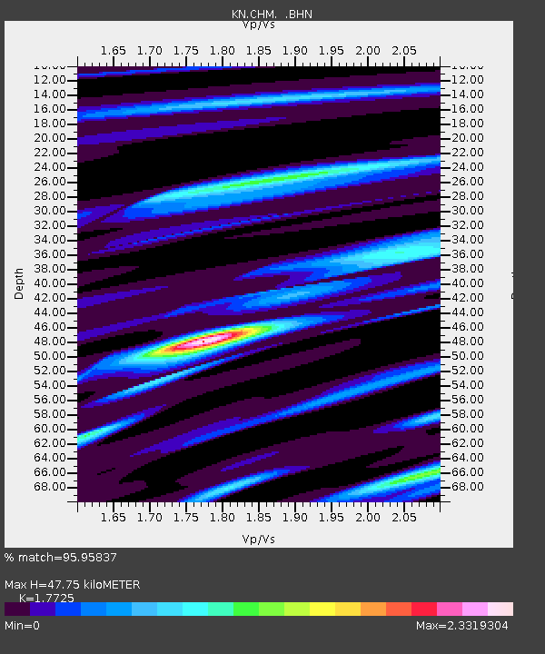
CHM KN.CHM - Earthquake Result Viewer
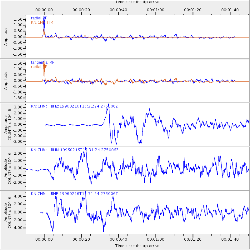
Earthquake location: Off East Coast Of Honshu, Japan
Earthquake latitude/longitude: 37.3/142.5
Earthquake time(UTC): 1996/02/16 (047) 15:22:57 GMT
Earthquake Depth: 33 km
Earthquake Magnitude: 6.2 MB, 6.2 MS, 6.7 UNKNOWN, 6.6 MW
Earthquake Catalog/Contributor: WHDF/NEIC
Network: KN Kyrgyz Seismic Telemetry Network
Station: CHM KN.CHM
Lat/Lon: 43.00 N/74.75 E
Elevation: 655 m
Distance: 50.8 deg
Az: 298.823 deg
Baz: 72.126 deg
Ray Param: 0.06775532
Estimated Moho Depth: 47.75 km
Estimated Crust Vp/Vs: 1.77
Assumed Crust Vp: 6.306 km/s
Estimated Crust Vs: 3.558 km/s
Estimated Crust Poisson's Ratio: 0.27
Radial Match: 95.95837 %
Radial Bump: 360
Transverse Match: 80.90373 %
Transverse Bump: 400
SOD ConfigId: 6273
Insert Time: 2010-03-08 19:28:12.705 +0000
GWidth: 2.5
Max Bumps: 400
Tol: 0.001

Signal To Noise

ChannelStoNSTALTA
KN:CHM: :BHN:19960216T15:31:24.275006Z3.06515467.068812E-72.3061845E-7
KN:CHM: :BHE:19960216T15:31:24.275006Z24.9082812.0210312E-68.113893E-8
KN:CHM: :BHZ:19960216T15:31:24.275006Z23.7661021.6044306E-66.7509205E-8
Arrivals
Ps6.2 SECOND
PpPs20 SECOND
PsPs/PpSs26 SECOND