You are here: Home > Network List > AV - Alaska Volcano Observatory Stations List
> Station SPCR Ckakachatna River, Mount Spurr, Alaska > Earthquake Result Viewer
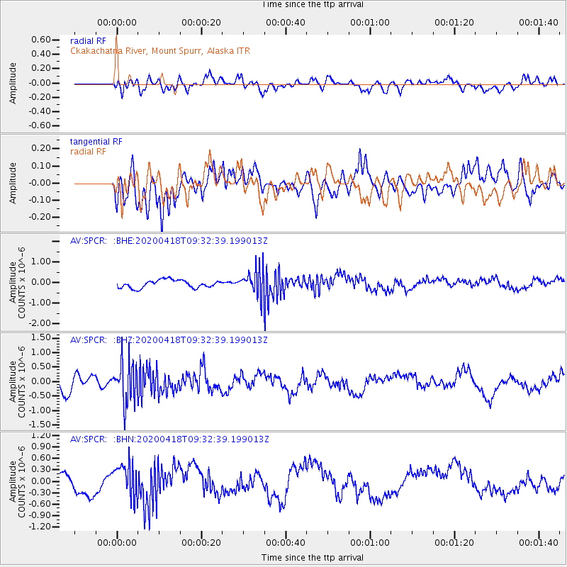
SPCR Ckakachatna River, Mount Spurr, Alaska - Earthquake Result Viewer
*The percent match for this event was below the threshold and hence no stack was calculated.
| Earthquake location: |
Bonin Islands, Japan Region |
| Earthquake latitude/longitude: |
27.2/140.1 |
| Earthquake time(UTC): |
2020/04/18 (109) 09:24:17 GMT |
| Earthquake Depth: |
468 km |
| Earthquake Magnitude: |
5.7 Mww |
| Earthquake Catalog/Contributor: |
NEIC PDE/us |
|
| Network: |
AV Alaska Volcano Observatory |
| Station: |
SPCR Ckakachatna River, Mount Spurr, Alaska |
| Lat/Lon: |
61.20 N/152.21 W |
| Elevation: |
984 m |
|
| Distance: |
55.9 deg |
| Az: |
32.776 deg |
| Baz: |
264.776 deg |
| Ray Param: |
$rayparam |
*The percent match for this event was below the threshold and hence was not used in the summary stack. |
|
| Radial Match: |
53.130978 % |
| Radial Bump: |
400 |
| Transverse Match: |
42.92187 % |
| Transverse Bump: |
400 |
| SOD ConfigId: |
21166931 |
| Insert Time: |
2020-05-02 09:29:39.104 +0000 |
| GWidth: |
2.5 |
| Max Bumps: |
400 |
| Tol: |
0.001 |
|
Signal To Noise
| Channel | StoN | STA | LTA |
| AV:SPCR: :BHZ:20200418T09:32:39.199013Z | 2.7317736 | 7.1783523E-7 | 2.627726E-7 |
| AV:SPCR: :BHN:20200418T09:32:39.199013Z | 1.6537421 | 4.6518485E-7 | 2.8129224E-7 |
| AV:SPCR: :BHE:20200418T09:32:39.199013Z | 3.435187 | 6.560505E-7 | 1.9097955E-7 |
| Arrivals |
| Ps | |
| PpPs | |
| PsPs/PpSs | |


