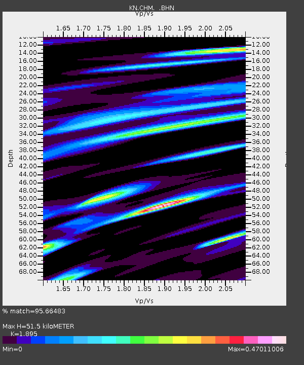
CHM KN.CHM - Earthquake Result Viewer
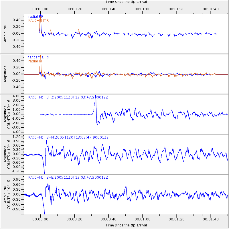
Earthquake location: Unimak Island Region, Alaska
Earthquake latitude/longitude: 53.8/-164.1
Earthquake time(UTC): 2005/11/20 (324) 12:53:02 GMT
Earthquake Depth: 30 km
Earthquake Magnitude: 5.7 MB, 5.8 MS, 6.2 MW, 6.0 MW
Earthquake Catalog/Contributor: WHDF/NEIC
Network: KN Kyrgyz Seismic Telemetry Network
Station: CHM KN.CHM
Lat/Lon: 43.00 N/74.75 E
Elevation: 655 m
Distance: 71.2 deg
Az: 318.451 deg
Baz: 32.393 deg
Ray Param: 0.05444922
Estimated Moho Depth: 51.5 km
Estimated Crust Vp/Vs: 1.89
Assumed Crust Vp: 6.306 km/s
Estimated Crust Vs: 3.328 km/s
Estimated Crust Poisson's Ratio: 0.31
Radial Match: 95.66483 %
Radial Bump: 379
Transverse Match: 90.25806 %
Transverse Bump: 400
SOD ConfigId: 2448
Insert Time: 2010-03-08 19:29:23.655 +0000
GWidth: 2.5
Max Bumps: 400
Tol: 0.001

Signal To Noise

ChannelStoNSTALTA
KN:CHM: :BHN:20051120T13:03:47.900012Z14.4721256.0075837E-74.1511413E-8
KN:CHM: :BHE:20051120T13:03:47.900012Z14.9096244.8667147E-73.264143E-8
KN:CHM: :BHZ:20051120T13:03:47.900012Z26.0089361.8151072E-66.978783E-8
Arrivals
Ps7.5 SECOND
PpPs23 SECOND
PsPs/PpSs30 SECOND