You are here: Home > Network List > US - United States National Seismic Network Stations List
> Station AMTX Amarillo, Texas, USA > Earthquake Result Viewer
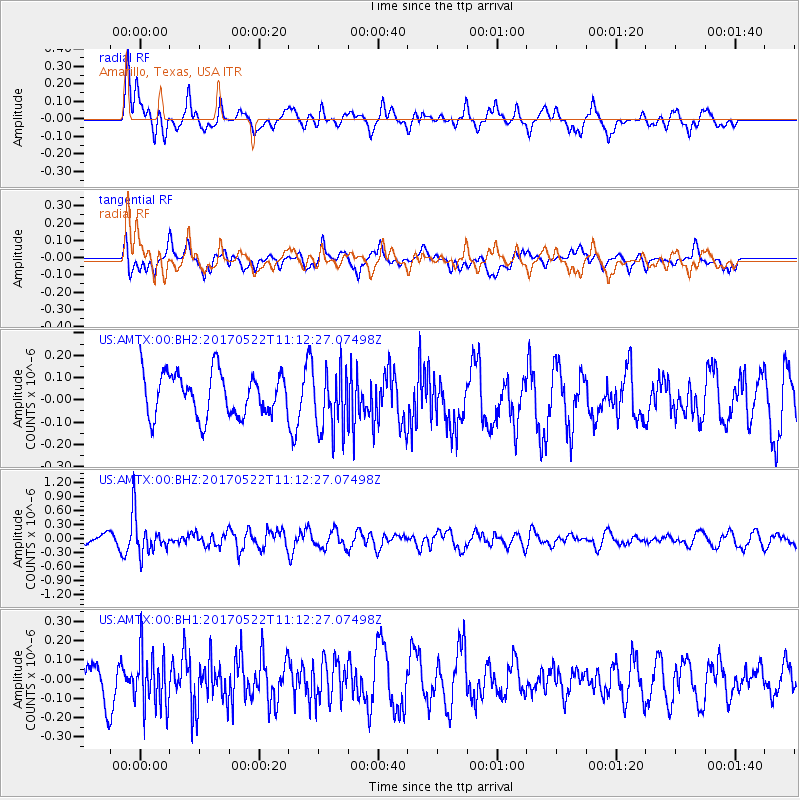
AMTX Amarillo, Texas, USA - Earthquake Result Viewer
*The percent match for this event was below the threshold and hence no stack was calculated.
| Earthquake location: |
Kuril Islands |
| Earthquake latitude/longitude: |
43.9/147.7 |
| Earthquake time(UTC): |
2017/05/22 (142) 11:00:57 GMT |
| Earthquake Depth: |
54 km |
| Earthquake Magnitude: |
5.5 Mww |
| Earthquake Catalog/Contributor: |
NEIC PDE/us |
|
| Network: |
US United States National Seismic Network |
| Station: |
AMTX Amarillo, Texas, USA |
| Lat/Lon: |
34.53 N/101.41 W |
| Elevation: |
1010 m |
|
| Distance: |
79.8 deg |
| Az: |
51.617 deg |
| Baz: |
316.681 deg |
| Ray Param: |
$rayparam |
*The percent match for this event was below the threshold and hence was not used in the summary stack. |
|
| Radial Match: |
71.341385 % |
| Radial Bump: |
400 |
| Transverse Match: |
49.786167 % |
| Transverse Bump: |
400 |
| SOD ConfigId: |
2028011 |
| Insert Time: |
2017-06-05 11:08:32.557 +0000 |
| GWidth: |
2.5 |
| Max Bumps: |
400 |
| Tol: |
0.001 |
|
Signal To Noise
| Channel | StoN | STA | LTA |
| US:AMTX:00:BHZ:20170522T11:12:27.07498Z | 3.108965 | 3.773124E-7 | 1.213627E-7 |
| US:AMTX:00:BH1:20170522T11:12:27.07498Z | 1.5066087 | 1.4781216E-7 | 9.810918E-8 |
| US:AMTX:00:BH2:20170522T11:12:27.07498Z | 1.3702246 | 1.3779628E-7 | 1.0056474E-7 |
| Arrivals |
| Ps | |
| PpPs | |
| PsPs/PpSs | |


