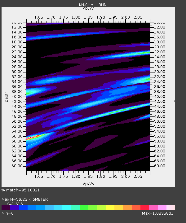
CHM KN.CHM - Earthquake Result Viewer
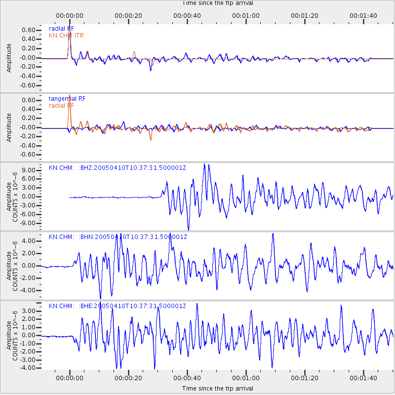
Earthquake location: Southern Sumatra, Indonesia
Earthquake latitude/longitude: -1.6/99.6
Earthquake time(UTC): 2005/04/10 (100) 10:29:11 GMT
Earthquake Depth: 19 km
Earthquake Magnitude: 6.4 MB, 6.7 MS, 6.7 MW, 6.6 MW
Earthquake Catalog/Contributor: WHDF/NEIC
Network: KN Kyrgyz Seismic Telemetry Network
Station: CHM KN.CHM
Lat/Lon: 43.00 N/74.75 E
Elevation: 655 m
Distance: 49.8 deg
Az: 336.171 deg
Baz: 146.601 deg
Ray Param: 0.06847645
Estimated Moho Depth: 56.25 km
Estimated Crust Vp/Vs: 1.62
Assumed Crust Vp: 6.306 km/s
Estimated Crust Vs: 3.905 km/s
Estimated Crust Poisson's Ratio: 0.19
Radial Match: 95.10021 %
Radial Bump: 332
Transverse Match: 87.30088 %
Transverse Bump: 400
SOD ConfigId: 2459
Insert Time: 2010-03-08 19:30:01.822 +0000
GWidth: 2.5
Max Bumps: 400
Tol: 0.001

Signal To Noise

ChannelStoNSTALTA
KN:CHM: :BHN:20050410T10:37:31.500001Z11.6995371.0925058E-69.3380265E-8
KN:CHM: :BHE:20050410T10:37:31.500001Z16.036268.9987816E-75.6115212E-8
KN:CHM: :BHZ:20050410T10:37:31.500001Z26.574082.4912295E-69.3746586E-8
Arrivals
Ps5.8 SECOND
PpPs22 SECOND
PsPs/PpSs28 SECOND