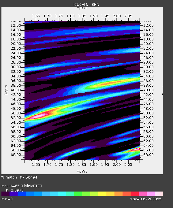
CHM KN.CHM - Earthquake Result Viewer

Earthquake location: Near East Coast Of Honshu, Japan
Earthquake latitude/longitude: 38.3/142.0
Earthquake time(UTC): 2005/08/16 (228) 02:46:28 GMT
Earthquake Depth: 36 km
Earthquake Magnitude: 6.5 MB, 6.8 MS, 7.2 MW, 7.1 MW
Earthquake Catalog/Contributor: WHDF/NEIC
Network: KN Kyrgyz Seismic Telemetry Network
Station: CHM KN.CHM
Lat/Lon: 43.00 N/74.75 E
Elevation: 655 m
Distance: 50.0 deg
Az: 298.016 deg
Baz: 71.276 deg
Ray Param: 0.06824064
Estimated Moho Depth: 65.0 km
Estimated Crust Vp/Vs: 2.10
Assumed Crust Vp: 6.306 km/s
Estimated Crust Vs: 3.006 km/s
Estimated Crust Poisson's Ratio: 0.35
Radial Match: 97.50494 %
Radial Bump: 263
Transverse Match: 91.6441 %
Transverse Bump: 400
SOD ConfigId: 2475
Insert Time: 2010-03-08 19:30:13.191 +0000
GWidth: 2.5
Max Bumps: 400
Tol: 0.001

Signal To Noise

ChannelStoNSTALTA
KN:CHM: :BHN:20050816T02:54:48.949011Z10.4277722.3329608E-62.2372572E-7
KN:CHM: :BHE:20050816T02:54:48.949011Z47.2738047.798382E-61.6496203E-7
KN:CHM: :BHZ:20050816T02:54:48.949011Z159.858951.4309475E-58.951313E-8
Arrivals
Ps12 SECOND
PpPs30 SECOND
PsPs/PpSs42 SECOND