You are here: Home > Network List > TA - USArray Transportable Network (new EarthScope stations) Stations List
> Station D25K Kavik River, AK, USA > Earthquake Result Viewer
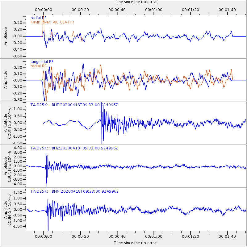
D25K Kavik River, AK, USA - Earthquake Result Viewer
*The percent match for this event was below the threshold and hence no stack was calculated.
| Earthquake location: |
Bonin Islands, Japan Region |
| Earthquake latitude/longitude: |
27.2/140.1 |
| Earthquake time(UTC): |
2020/04/18 (109) 09:24:17 GMT |
| Earthquake Depth: |
468 km |
| Earthquake Magnitude: |
5.7 Mww |
| Earthquake Catalog/Contributor: |
NEIC PDE/us |
|
| Network: |
TA USArray Transportable Network (new EarthScope stations) |
| Station: |
D25K Kavik River, AK, USA |
| Lat/Lon: |
69.32 N/146.38 W |
| Elevation: |
770 m |
|
| Distance: |
59.0 deg |
| Az: |
23.407 deg |
| Baz: |
265.032 deg |
| Ray Param: |
$rayparam |
*The percent match for this event was below the threshold and hence was not used in the summary stack. |
|
| Radial Match: |
69.999916 % |
| Radial Bump: |
400 |
| Transverse Match: |
70.031906 % |
| Transverse Bump: |
400 |
| SOD ConfigId: |
21166931 |
| Insert Time: |
2020-05-02 09:40:48.690 +0000 |
| GWidth: |
2.5 |
| Max Bumps: |
400 |
| Tol: |
0.001 |
|
Signal To Noise
| Channel | StoN | STA | LTA |
| TA:D25K: :BHZ:20200418T09:33:00.924996Z | 7.3951344 | 1.0812713E-6 | 1.4621388E-7 |
| TA:D25K: :BHN:20200418T09:33:00.924996Z | 4.1252623 | 4.1333612E-7 | 1.0019633E-7 |
| TA:D25K: :BHE:20200418T09:33:00.924996Z | 3.4489853 | 5.917078E-7 | 1.7155996E-7 |
| Arrivals |
| Ps | |
| PpPs | |
| PsPs/PpSs | |


