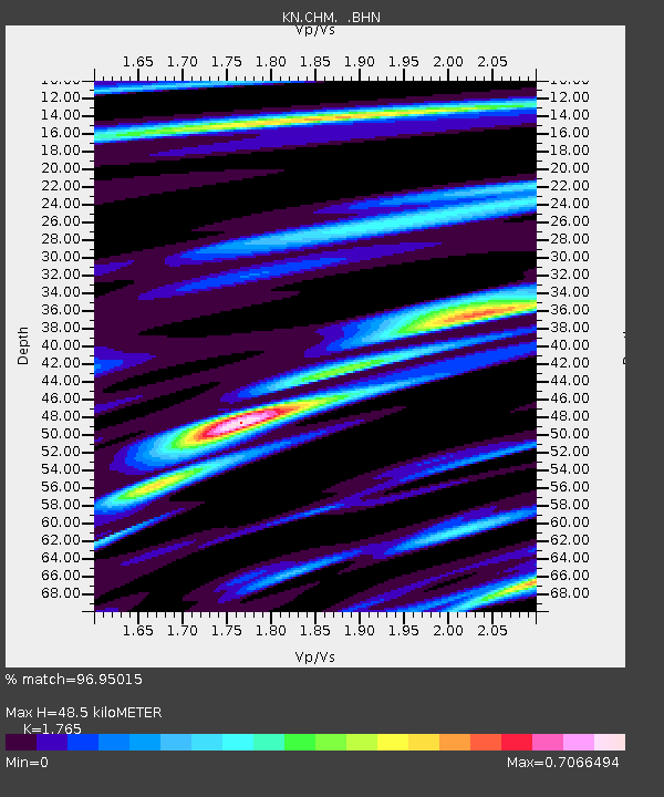
CHM KN.CHM - Earthquake Result Viewer
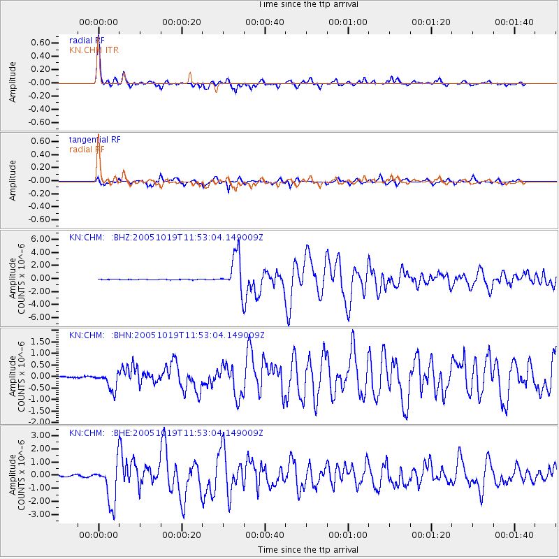
Earthquake location: Near East Coast Of Honshu, Japan
Earthquake latitude/longitude: 36.4/140.8
Earthquake time(UTC): 2005/10/19 (292) 11:44:42 GMT
Earthquake Depth: 32 km
Earthquake Magnitude: 6.2 MB, 6.5 MS, 6.4 MW, 6.3 MW
Earthquake Catalog/Contributor: WHDF/NEIC
Network: KN Kyrgyz Seismic Telemetry Network
Station: CHM KN.CHM
Lat/Lon: 43.00 N/74.75 E
Elevation: 655 m
Distance: 50.1 deg
Az: 299.047 deg
Baz: 74.012 deg
Ray Param: 0.068219885
Estimated Moho Depth: 48.5 km
Estimated Crust Vp/Vs: 1.76
Assumed Crust Vp: 6.306 km/s
Estimated Crust Vs: 3.573 km/s
Estimated Crust Poisson's Ratio: 0.26
Radial Match: 96.95015 %
Radial Bump: 317
Transverse Match: 89.14369 %
Transverse Bump: 400
SOD ConfigId: 2475
Insert Time: 2010-03-08 19:30:20.536 +0000
GWidth: 2.5
Max Bumps: 400
Tol: 0.001

Signal To Noise

ChannelStoNSTALTA
KN:CHM: :BHN:20051019T11:53:04.149009Z8.0509364.0253158E-74.999811E-8
KN:CHM: :BHE:20051019T11:53:04.149009Z31.8578171.6307869E-65.1189534E-8
KN:CHM: :BHZ:20051019T11:53:04.149009Z61.381972.9052906E-64.7331337E-8
Arrivals
Ps6.2 SECOND
PpPs20 SECOND
PsPs/PpSs26 SECOND