You are here: Home > Network List > TA - USArray Transportable Network (new EarthScope stations) Stations List
> Station G23K Bananza Creek, AK, USA > Earthquake Result Viewer
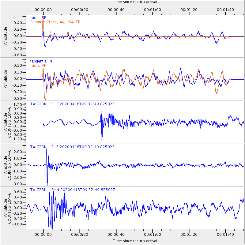
G23K Bananza Creek, AK, USA - Earthquake Result Viewer
*The percent match for this event was below the threshold and hence no stack was calculated.
| Earthquake location: |
Bonin Islands, Japan Region |
| Earthquake latitude/longitude: |
27.2/140.1 |
| Earthquake time(UTC): |
2020/04/18 (109) 09:24:17 GMT |
| Earthquake Depth: |
468 km |
| Earthquake Magnitude: |
5.7 Mww |
| Earthquake Catalog/Contributor: |
NEIC PDE/us |
|
| Network: |
TA USArray Transportable Network (new EarthScope stations) |
| Station: |
G23K Bananza Creek, AK, USA |
| Lat/Lon: |
66.71 N/150.02 W |
| Elevation: |
746 m |
|
| Distance: |
57.4 deg |
| Az: |
26.31 deg |
| Baz: |
263.18 deg |
| Ray Param: |
$rayparam |
*The percent match for this event was below the threshold and hence was not used in the summary stack. |
|
| Radial Match: |
63.95076 % |
| Radial Bump: |
400 |
| Transverse Match: |
58.189068 % |
| Transverse Bump: |
400 |
| SOD ConfigId: |
21166931 |
| Insert Time: |
2020-05-02 09:41:32.511 +0000 |
| GWidth: |
2.5 |
| Max Bumps: |
400 |
| Tol: |
0.001 |
|
Signal To Noise
| Channel | StoN | STA | LTA |
| TA:G23K: :BHZ:20200418T09:32:49.82502Z | 9.977231 | 9.77168E-7 | 9.7939804E-8 |
| TA:G23K: :BHN:20200418T09:32:49.82502Z | 2.9246976 | 2.9969118E-7 | 1.0246911E-7 |
| TA:G23K: :BHE:20200418T09:32:49.82502Z | 3.2678764 | 3.9578504E-7 | 1.2111383E-7 |
| Arrivals |
| Ps | |
| PpPs | |
| PsPs/PpSs | |


